
 United Kingdom
 France
 Germany
 Netherlands
 Sweden
 USA
USA
 Italy
Italy
 Spain
Spain
More From Contributor

Antwerp And Environs Pocket Atlas (Paperback)
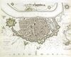
Antwerp and its conurbation on 155 pages of detailed street mapping, covering 49 communes in a paperback pocket atlas from De Rouck Geocart. The atlas provides continuous mapping for the whole area at 1:15, 000, with central Antwerp also shown at 1:12, 500.Streets which are part of the national road network are annotated with their road numbers and motorway junctions are shown with names. One way streets and tram lines are marked. Within the Antwerp port area dock names and quay numbers are shown together with names of main companies and businesses trading there.A wide range of symbols highlight various institutions, facilities and services. The maps have no geographical coordinates (i.e. no UTM or latitude and longitude, but they do show 500m lines of the Lambert projection of Belgium
Product Description
Reviews/Comments
Add New
Intelligent Comparison
Archived Product

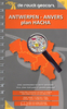
Antwerp And Environs Pocket Atlas (Spiral-bound) Stanfords
£15.95
Vouchers
No voucher codes found.
Do you know a voucher code for this product or supplier? Add it to Insights for others to use.
Do you know a voucher code for this product or supplier? Add it to Insights for others to use.
 Denmark