
 United Kingdom
 France
 Germany
 Netherlands
 Sweden
 USA
USA
 Italy
Italy
 Spain
Spain
More From Contributor


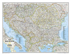


Balkan Peninsula
The Balkans at 1:1, 200, 000 on a double-sided map from the Bulgarian publishers Domino, showing the region’s road network in detail and presenting its geography with bright altitude colouring. Coverage with full detail includes Romania and Moldova; the whole of Hungary is also on the map but with information limited to larger towns and principal roads.The map shows a large number of small towns and villages and provides names of various mountain ranges, etc. Presentation of place names varies: - in Bulgaria names of larger town are in both Cyrillic and Latin alphabet; names smaller towns and villages and of geographical features are in Cyrillic only- in all the remaining countries (including Serbia) names of larger towns are in both scripts, with smaller locations and geographical
features in Latin alphabet onlyThe map is not indexed and has latitude and longitude lines at intervals of 1°. Map legend includes English.
features in Latin alphabet onlyThe map is not indexed and has latitude and longitude lines at intervals of 1°. Map legend includes English.

Product Description
Reviews/Comments
Add New
Vouchers
No voucher codes found.
Do you know a voucher code for this product or supplier? Add it to Insights for others to use.
Do you know a voucher code for this product or supplier? Add it to Insights for others to use.
 Denmark