
 United Kingdom
 France
 Germany
 Netherlands
 Sweden
 USA
USA
 Italy
Italy
 Spain
Spain
More From Contributor


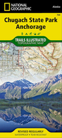
Chugach State Park, AK
Chugach State Park west of Anchorage in Alaska on a detailed map at 1:100, 000 from Imus Geographics vividly presenting its topography and showing various trails, access to mountain biking, ski, ATV and snowmobile routes, campgrounds, etc. Cartography is based on the USGS topographic survey mapping, with contours at 200 feet intervals, relief shading and colouring to show the forested areas and glaciers. Boundaries of the Chugach State Park, of other protected areas and of the adjoining military lands are clearly marked. Trails are divides into established (shown with mileage for individual sections), backcountry or mountaineering routes and paved paths, with notes on the reverse providing the definitions. Symbols indicate trail heads and access to mountain biking, ski, ATV and
snowmobile routes, plus campgrounds, ranger stations, etc. The map has a UTM grid.The whole of the reverse side is covered by notes providing information about the park, including campgrounds, fees, descriptions of trails, etc.
snowmobile routes, plus campgrounds, ranger stations, etc. The map has a UTM grid.The whole of the reverse side is covered by notes providing information about the park, including campgrounds, fees, descriptions of trails, etc.
Product Description
Reviews/Comments
Add New
Intelligent Comparison
Archived Product
Chugach State Park - Anchorage AK Stanfords
£9.99
Archived Product
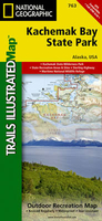
Kachemak Bay State Park AK Stanfords
£9.99
Vouchers
No voucher codes found.
Do you know a voucher code for this product or supplier? Add it to Insights for others to use.
Do you know a voucher code for this product or supplier? Add it to Insights for others to use.
 Denmark