
 United Kingdom
 France
 Germany
 Netherlands
 Sweden
 USA
USA
 Italy
Italy
 Spain
Spain
More From Contributor


Colorado Plateau - Canyonlands - Southern Rocky Mountains
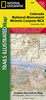
Colorado Plateau - Canyonlands - Southern Rocky Mountains map from Hildebrand, presenting at 1:700, 000 the region between Denver, Albuquerque, Phoenix and Las Vegas with highlighting for national parks and other protected areas, plus and overview map of south-western USA and a street plan of Phoenix.The main map at 1:700, 000 is spread over both sides of this title. On one side is most of Arizona, from Phoenix northwards, plus the southern part of Utah and the southern tip of Nevada with Las Vegas. On the reverse coverage is extended further east to north-western New Mexico with Albuquerque and south-western Colorado just short of Denver. The map prominently highlights the region’s numerous national parks and national/state forest, and other protected areas, plus clearly shows
Indian reservations and restricted military zones.Topography is indicated by relief shading with names of numerous individual mountain ranges and stop heights. Road network is graded into six types, from national highways to unsealed local roads. Scenic roads are highlighted and driving distances are marked on main routes. Railway lines are included and domestic airports are marked. The map indicates locations of campsites and various places of interest, is indexed (NB. very small print), and has latitude and longitude lines at intervals of 30’. Map legend includes English.A large inset at 1:3, 478, 000 approx provides an overview of wider area; between Denver and Los Angeles, and north/south from Salt Lake City to Phoenix. Also provided is a street plan of Phoenix showing access to
the Sky Harbor International Airport.National parks, other protected area and Indian reservations covered by this map include: Grand Canyon, Zion, Bryce Canyon, Arches, Capitol Reef, Glen Canyon - Lake Powell, Canyonlands, Monument Valley, Mesa Verde, Canyon de Chelly, Petrified Forest, plus Navajo and Hopi Indian Reservations.

Product Description
Reviews/Comments
Add New
Vouchers
No voucher codes found.
Do you know a voucher code for this product or supplier? Add it to Insights for others to use.
Do you know a voucher code for this product or supplier? Add it to Insights for others to use.
 Denmark