
 United Kingdom
 France
 Germany
 Netherlands
 Sweden
 USA
USA
 Italy
Italy
 Spain
Spain
More From Contributor

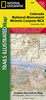


Colorado Recreational Map
Colorado Recreational Map at 1:790, 000 approx. from GTR in a series covering the Rocky Mountains states of USA on indexed topographic recreational maps designed to provide good presentation of each state’s geography, protected areas, recreational facilities and places of interest.Topography is presented by contours at 1000 feet intervals, enhanced by changes in altitude colouring every 2000’, plus names of mountain ranges. The network of rivers, lakes and reservoirs is shown in great detail, with numerous small rivers and creeks named and on some titles state fishing access sites are marked. National or state parks, recreational areas, forests, grassland, wildlife refuges, etc, are highlighted, as well as Indian Reservations and restricted access military basesRoad
network distinguishes between gravel and dirt surface local roads and indicates routes more suitable for 4WD vehicles. Driving distances are marked on main routes. Symbols indicate five different kinds of campgrounds. Also marked are picnic grounds and rest areas, skiing areas, and various other places of interest. A special feature of this series is the inclusion of symbols indicating mining districts with old mining and/or ghost towns. Each title is indexed and, unless specified to the contrary in its individual description, has no geographical coordinates.The reverse side of each map provides extensive tourist information with lists of national parks and other protected areas indicating what facilities can be found there, county by county lists of both various historical and
cultural places of interest and protected areas, lists of mining districts, etc. Also provided is a climate and mileage chart for each state.
Product Description
Reviews/Comments
Add New
Vouchers
No voucher codes found.
Do you know a voucher code for this product or supplier? Add it to Insights for others to use.
Do you know a voucher code for this product or supplier? Add it to Insights for others to use.
 Denmark