More From Contributor

£17.99
Waterproof & tear-resistant political wall map of the world from Freytag & Berndt, size 100x 70cm (39.5”x 27.5cm), which can be annotated with suitable write-on/wipe-off marker pens. Countries are in warm, earthy colours enhanced by physical shading to show mountain ranges, with oceans indicating the relief of the sea floor through different shades of light blue. Printed on thick synthetic paper, the map is in an international edition with all place names in their English versions. On land the shading indicates physical geography with names of main mountain ranges, deserts & peaks. In the oceans the variation in colouring vividly presents the sea floor with names of ridges, plateaux, basins, etc. Latitude & longitude lines are drawn at 10º intervals. Map legend is in English.PLEASE NOTE: this small version is also available with metal hanging strips. The map is also published in an extra large 202 x 130cm size which has considerably more place names. To see the other versions please click on the series link. ...
Archived Product
£8.99
Colour the World is a gorgeous travel colouring book for adults. Filled with beautiful line drawings allowing you to design your own colour scheme for some of the world`s most extraordinary travel destinations. Colour the World features sweeping landscapes
- such as the mysterious Inca site of Machu Picchu in Peru
- & mesmerising details from iconic sights, such as London`s Big Ben. There are also plenty of geometric patterns, from the ornate tile work at Istanbul`s Topkapi Palace to the stained-glass rose window of Notre Dame in Paris. Combining travel content with calming art therapy, you can leave your worries behind. Relieve stress by escaping on long journeys & unleash your creative streak. Why not paint Big Ben in rainbow colours or re-imagine Peru today with Colour the World.

...
Archived Product
£12.99
Festivals, camping, holidays
- portable chargers are great for any situation, & this World Map powerbank keyring is pretty as
...
Archived Product
£9.99
Explore the cartographic treasures of the British Library`s extensive map archive, & add your own colour. Early maps are often much more highly decorated than our own, featuring fantastical drawings of real or imaginary people & animals that may or may not occupy unknown places. Medieval maps look very different to the maps of today. Significant places were given prominence & historical or religious events were frequently included. This new colouring book is packed with a series of fascinating hand drawn maps carefully selected from the extensive collection of the British Library, which

Includes::
charters & seals, medieval historical & iconic atlas` from Queen Mary I`s personal collection & King George III`s to detailed drawings from well-known artists such as Nicolas Sanson & William Hack. Each of the original maps is reproduced in colour, so that you can decide whether you prefer to choose your own colours, or to use the colours that the cartographer intended. With key facts about each of the maps, this is the perfect book for geography lovers, history buffs & colouring-in fanatics alike.

...
Archived Product
£8.99
The groundbreaking new colouring book that turns your pictures into animated films. Colour in the pictures, take photos using the free app & create your very own animated films based on your drawings. In this fun & exciting colouring book, colour in 16 pictures, create 16 animated episodes & make a total of 8 minutes of animated film simply by using the free app, available on your smartphone or tablet. As you colour & watch your pictures move, also discover how animals use their colours & markings in surprising ways. ...
Archived Product
£12.99
Part travelogue, part narrative history, ` Colour` unlocks the history of the colours of the rainbow, & reveals how paints came to be invented, discovered, traded & used. This remarkable & beautifully written book remembers a time when red paint was really the colour of blood, when orange was the poison pigment, blue as expensive as gold, & yellow made from the urine of cows force-fed with mangoes. It looks at how green was carried by yaks along the silk road, & how an entire nation was founded on the colour violet. Exciting, richly informative, & always surprising, ` Colour` lifts the lid on the historical palette & unearths an astonishing wealth of stories about the quest for colours, & our efforts to understand them. ...
Archived Product
£4.99
The Colourful Cactus Foldable Shopping Bag, comes as a compact & colourful pouch in the shape of an Cactus & unfolds into a tote bag featuring a delicate decorative print. Very lightweight, the little Cactus can fit any handbag & be ready to use as an alternative to a plastic bag. The Colourful Cactus Foldable Shopping Bag is ideal for when you pop out to get your lunch or a few items from the shops. ...
Archived Product
£16.95
From Mali to Peru, from China to Norway, here is a fascinating journey of discovery that captures all the colours of the world & reveals the all-pervasive influence of colour in our lives. Scores of photographs are organized into colour-coded chapters that reveal the many different ways colour is used & perceived around the world. This vibrant book will be a source of inspiration & delight for designers & artists everywhere. ...
Archived Product
£1.99
This is a selection of attractive pictures for children to colour, based on the powerful & sophisticated civilization of the ancient Aztecs. The Aztecs established a great empire in central Mexico about 600 years ago, before the arrival of the Spanish under Hernan Cortes in 1519. They were a warlike people who exacted tribute from other people, yet they also built great cities & temples, & made beautiful objects of stone, metal, gems & feathers. ...
Archived Product

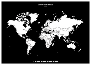
Colour! World Colour In Map

This minimalist map is by far the most creative way to keep track of your adventures. Colour the whole countries or mark precise points on the map. Mark your travel route from one place to another. Write down memories, add drawings or attach photos. At the bottom of the map you’ll find a legend. Use the squares to mark your journey with different colours or patterns. You can even assign squares to family and friends to show their journeys too.The size of the map is ideal for framing, but you can just attach it on the wall with any tape or sticker.
RIP - This product is no longer available on our network. It was last seen on 25.09.2019

This page now acts as a permanent archive for this product. Add more information using the comments box below to ensure it can still be found by future generations.

Use our search facility to see if it is available from an alternative contributor.
  • Availability: Out Of Stock
  • Supplier: Stanfords
  • SKU: 4744047010061
Availability: In Stock
£22.99

Product Description

This minimalist map is by far the most creative way to keep track of your adventures. Colour the whole countries or mark precise points on the map. Mark your travel route from one place to another. Write down memories, add drawings or attach photos. At the bottom of the map you’ll find a legend. Use the squares to mark your journey with different colours or patterns. You can even assign squares to family & friends to show their journeys too. The size of the map is ideal for framing, but you can just attach it on the wall with any tape or sticker.

Reviews/Comments

Add New

Intelligent Comparison

Oooops!
We couldn't find anything!
Perhaps this product's unique.... Or perhaps we are still looking for comparisons!
Click to bump this page and we'll hurry up.

Price History

Vouchers

No voucher codes found.
Do you know a voucher code for this product or supplier? Add it to Insights for others to use.

Facebook

Jargon Buster

Wall - A physical barrier between two areas
Friends - A close associate or a popular US based sitcom about a group of friends
World - A physical grouping, commonly used to describe earth and everything associated with ti
Colour - The categorised spectrum of light visable to humans
Size - is the measurement of how big an object is in space.
Precise - A measurement on the accuracy of something
Sticker - A label that has an adhesive glue on the back and generally pictures on the front.
Ideal - Something that satisfies a perfect criteria.
Family - A group of people that live together made up from parents and children.

Supplier Information

Stanfords
Stanfords was established in 1853 and opened their iconic Covent Garden flagship store in 1901. They have become the top retailer of maps, travel books and accessories in the UK and arguably offer the largest selection of maps and travel books worldwide. Famous names such as Captain Robert Falcon Scott, Ranulph Fiennes and Michael Palin have purchased from Stanfords. They now have a shop in Bristol and both stores together with other venues operate a calendar of events including talks, book signings and exhibitions. As a specialist map retailer, the map selection is comprehensive and includes road maps, street maps and walking maps from worldwide destinations, as well as a selection of world atlases and wall maps. Books include travel guides and travel literature. Stanfords also stock globes, from miniatures made of blue marble to magnificent floor-standing globes. The website features a selection of interesting articles on travel topics.
Page Updated: 2023-11-12 20:15:36

Community Generated Product Tags

Oh No! The productWIKI community hasn't generated any tags for this product yet!
Menu