
 United Kingdom
 France
 Germany
 Netherlands
 Sweden
 USA
USA
 Italy
Italy
 Spain
Spain
More From Contributor


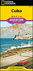

Cuba Borch
Laminated and waterproof tourist road map of Cuba, with street plans of Havana, Playa del Este, Santiago de Cuba and Varadero. The main map divides the country east/west and shows its road and railways networks. Places of interest, including national parks, numerous beaches, yachting centres, windsurfing and scuba diving sites, etc, are highlighted. Topography of the island is shown by relief shading with marking for mangroves, swamps and the surrounding coral reefs.Street plans show central Havana, Playa del Este, Santiago and the Varadero strips, showing selected hotels, various facilities and places of interest. Both the main map and all the street plans are indexed with lists of locations/streets, beaches, places of interest, etc. Also included is information on the
island’s climate with temperature, precipitation, etc., charts.
island’s climate with temperature, precipitation, etc., charts.

Product Description
Reviews/Comments
Add New
Intelligent Comparison
Archived Product

Aruba Borch Stanfords
£9.99
Archived Product

Dublin Borch Stanfords
£8.99
Vouchers
No voucher codes found.
Do you know a voucher code for this product or supplier? Add it to Insights for others to use.
Do you know a voucher code for this product or supplier? Add it to Insights for others to use.
 Denmark