
 United Kingdom
 France
 Germany
 Netherlands
 Sweden
 USA
USA
 Italy
Italy
 Spain
Spain
More From Contributor


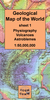
Geological Map Of The British Islands BGS
Folded version of the Geological Map of the British Islands at 1:1, 584, 000 (1” to 25 miles) from the British Geological Survey, showing the bedrock (formerly ‘solid’) geology of the whole of the UK, Ireland, the Channel Islands and part of the English Channel coastline of France. The disposition at surface (outcrops) of the major rock types and named rock units are shown, with a geological map key giving the scale of geochronological eras and chronostratigraphical systems.The currently available edition is a 2014 reprint of the map’s 5th edition originally published in 1969. The underlying base map shows important towns and cities, main roads, major rivers, significant topographical features, and pre-1965 counties.Please note: this map is also available as a wall map.
Product Description
Reviews/Comments
Add New
Vouchers
No voucher codes found.
Do you know a voucher code for this product or supplier? Add it to Insights for others to use.
Do you know a voucher code for this product or supplier? Add it to Insights for others to use.
 Denmark