More From Contributor

£7.99
In Soviet Russia, a triple murder in Moscow amusement centre, Gorky Park, leaves three corpses frozen in the snow. But when Senior Investigator in the Moscow Prosecutor`s Office Arkady Renko arrives, he finds that the brutal murder leaves the victims unidentifiable with faces & fingers missing. Renko must battle political & corporate corruption internationally, from the USSR to the USA, to uncover the truth
- & he must fight for his own life in doing so. Meanwhile, he is falling in love with a beautiful, headstrong dissident for whom he may risk everything.
...
Archived Product
£7.99
Three bodies found frozen in the snow. & the hunt for the killer begins…A triple murder in Moscow’s famous Gorky Park amusement centre rocks the capital – three corpses found in the snow, so badly mutilated that their identities can’t be verified. Chief Investigator Arkady Renko from the Moscow police takes the case. Renko is a brilliant investigator – dangerously so. Now, to identify the victims & uncover the truth, he must battle the KGB, FBI & the police – & stay alive doing it…. ...
Archived Product
£2.95
Gorleston in 1904 in a fascinating series of reproductions of old Ordnance Survey plans in the Alan Godfrey Editions, ideal for anyone interested in the history of their neighbourhood or family. Selected towns in Great Britain & Ireland are covered by maps showing the extent of urban development in the last decades of the 19th & early 20th century. In this title: Yarmouth & Gorleston area is covered by four maps. The southern three include areas of Suffolk
- the relevant Suffolk sheet numbers being 2.03, 2.07 & 2.11. GREAT YARMOUTH NORTH map covers the northern part of Yarmouth from St Nicholas church northward. Features include Vauxhall station, Runham Vauxhall, Workhouse, Old & New Cemeteries, Beach station, Breydon Viaduct, St Nicholas church, Old Recreation Ground, Falcon Brewery, tramways, railway approaches, Infectious Diseases Hospital, Vauxhall Bridge, etc. On the reverse we include extracts from a directory re councillors & public establishments. GREAT YARMOUTH map covers the centre of Yarmouth, stretching from St Nicholas Road & Priory Plain southward to the Royal Naval Hospital, & from the coast inland to the Midland & Gt Northern railway (but note that the main station is north of this map). Features include the River Yare, East Suffolk line with station, Southtown, Cobholm Isl&, Market Place, King Street, St Georges Park, Britannia Pier, The Jetty, Wellington Pier, Winter Gardens, tramways, Town Hall, South Quay, railway lines along quay. A major feature is the extraordinary range of narrow yards, streets & rows on what was the medieval centre; many of these disappeared during bombing in the 2nd World War. On the reverse directory extracts lists the private residents A-H. YARMOUTH SOUTH & GORLESTON NORTH map continues coverage southward to Gorleston Priory. Features here include the Royal Artillery Barracks, Nelson's Monument, South Beach, Fish Wharf, Southtown Common, Gorleston North station, Malthouse Quay, Otter's Farm, northern part of Gorleston High Street. Coverage extends west into countryside & Bradwell House & Gapton Hall. Yarmouth directory entries H-Z are included. GORLESTON map shows the centre of Gorleston, with coverage continuing south to Gorleston-on-Sea station. Features include St Andrew's church, South Pier, lighthouses at harbour entrance, Cliff Hotel, Brush Quay, West Quay, Ballast Quay, High St, Pier Plain, Lowestoft Road, cemetery, Shrubland Farm, isolation hospital. A directory of Gorleston is included. About the Alan Godfrey Editions of the 25
...
Archived Product
£3.50
Gorleston in 1904 in a fascinating series of reproductions of old Ordnance Survey plans in the Alan Godfrey Editions, ideal for anyone interested in the history of their neighbourhood or family. Great Yarmouth in 1904 in a fascinating series of reproductions of old Ordnance Survey plans in the Alan Godfrey Editions, ideal for anyone interested in the history of their neighbourhood or family. Yarmouth & Gorleston area is covered by four maps. GREAT YARMOUTH NORTH map covers the northern part of Yarmouth from St Nicholas church northward. Features include Vauxhall station, Runham Vauxhall, Workhouse, Old & New Cemeteries, Beach station, Breydon Viaduct, St Nicholas church, Old Recreation Ground, Falcon Brewery, tramways, railway approaches, Infectious Diseases Hospital, Vauxhall Bridge, etc. On the reverse are extracts from a directory re councillors & public establishments. GREAT YARMOUTH map covers the centre of Yarmouth, stretching from St Nicholas Road & Priory Plain southward to the Royal Naval Hospital, & from the coast inland to the Midland & Gt Northern railway (but note that the main station is north of this map). Features include the River Yare, East Suffolk line with station, Southtown, Cobholm Isl&, Market Place, King Street, St Georges Park, Britannia Pier, The Jetty, Wellington Pier, Winter Gardens, tramways, Town Hall, South Quay, railway lines along quay. A major feature is the extraordinary range of narrow yards, streets & rows in what was the medieval centre
- many of these disappeared during bombing in World War II. On the reverse directory extracts lists the private residents A to H. YARMOUTH SOUTH & GORLESTON NORTH map continues coverage southward to Gorleston Priory. Features here include the Royal Artillery Barracks, Nelson`s Monument, South Beach, Fish Wharf, Southtown Common, Gorleston North station, Malthouse Quay, Otter`s Farm, northern part of Gorleston High Street, etc. Coverage extends west into countryside & Bradwell House & Gapton Hall. Yarmouth directory entries H to Z are on the reverse. This GORLESTON map shows the centre of Gorleston, with coverage continuing south to Gorleston-on-Sea station. Features include St Andrew`s church, South Pier, lighthouses at harbour entrance, Cliff Hotel, Brush Quay, West Quay, Ballast Quay, High St, Pier Plain, Lowestoft Road, cemetery, Shrubland Farm, isolation hospital. A directory of Gorleston on the reverse. About the Alan Godfrey Editions of the 25” OS Series: Selected towns in Great Britain & Ireland are covered by maps showing the extent of urban development in the last decades of the 19th & early 20th century. The plans have been taken from the Ordnance Survey mapping & reprinted at about 15 inches to one mile (1:4, 340). On the reverse most maps have historical notes & many also include extracts from contemporary directories. Most maps cover about one mile (1.6kms) north/south, one & a half miles (2.4kms) across; adjoining sheets can be combined to provide wider coverage.FOR MORE INFORMATION & A COMPLETE LIST OF ALL AVAILABLE TITLES PLEASE CLICK ON THE SERIES LINK.
...
Archived Product
£8.99
Gorlitz on a topographic map at 1:200, 000 from the Bundesamt für Kartographie und Geodäsie, Germany’s federal mapping agency. The map covers an area of Approx. 100 x 90km. This map is belongs to a series of 58 topographic maps from Bundesamt für Kartographie und Geodäsie, the federal cartographic agency of Germany responsible for topographic mapping at 1:200, 000 & maps at smaller scales (the more detailed topographic & leisure maps are prepared & published by the survey organizations of the individual states). Cartography is from the 200K topographic survey & the maps have very elegant, modern look whilst retaining the traditional German presentation of names of smaller towns & villages in italics. Contours are at 12, 5m intervals, enhanced by relief shading, with colouring for woodlands, moors, marches, vineyards & hop plantations. Waterways & rivers are also described in detail, with currents, waterfalls, dams, & jetties clearly marked. Road network, graded into five types, highlights in colour national & regional roads; no driving distances are marked Railway network is also shown in detail, with stations, goods only lines, etc. The maps show administrative boundaries of states & counties, & have a UTM grid plus margin ticks for latitude & longitude at 2’ intervals. Map legend is in German only. PLEASE NOTE: maps in this series provide an excellent presentation of the areas covered by them, with plenty of place names & detailed representation of the road network, & will appeal to anyone who likes quality cartography, but they are not necessarily the best option for holiday & business travel. To see other titles in this series please click on the series link. ...
Archived Product
£3.50
Gornalwood & Himley Coalfield in 1901 in a fascinating series of reproductions of old Ordnance Survey plans in the Alan Godfrey Editions, ideal for anyone interested in the history of their neighbourhood or family. The map covers Gornalwood & the area westward to Straits Green (in the centre of the map) & Himley Wood. Features include St John`s church, chapels, Redhall, old coal shafts, Ruiton Farm, Ellowes Hall, brick works, Straits Green, Turner`s Hill Wood, Turner`s Hill, Wallows Wood, Gordon`s Place, Straits House, Himley Colliery, Higharcal, mineral railway & tramway, Himley Wood, etc. On the reverse is a section of the 1913 revision, showing the Himley Colliery area at a later date. About the Alan Godfrey Editions of the 25” OS Series: Selected towns in Great Britain & Ireland are covered by maps showing the extent of urban development in the last decades of the 19th & early 20th century. The plans have been taken from the Ordnance Survey mapping & reprinted at about 15 inches to one mile (1:4, 340). On the reverse most maps have historical notes & many also include extracts from contemporary directories. Most maps cover about one mile (1.6kms) north/south, one & a half miles (2.4kms) across; adjoining sheets can be combined to provide wider coverage.FOR MORE INFORMATION & A COMPLETE LIST OF ALL AVAILABLE TITLES PLEASE CLICK ON THE SERIES LINK. ...
Archived Product
£2.95
Gorton & Belle Vue in 1905 in a fascinating series of reproductions of old Ordnance Survey plans in the Alan Godfrey Editions, ideal for anyone interested in the history of their neighbourhood or family. Selected towns in Great Britain & Ireland are covered by maps showing the extent of urban development in the last decades of the 19th & early 20th century. In this title: the map covers the area of south-east Manchester around Belle Vue, extending eastward to Gorton. Coverage stretches from Slade Lane eastward to Hyde Road station, & from Hector Street northward to Great Jackson Street. Features include Belle Vue Zoological Gardens, Nutsford Vale, St Cyprian's church, Kirkmanshulme House, football ground, Imperial Brewery, tramways, Tarpaulin Works, sewage works, Catsknowl, Gorton Park, railway stretches with Belle Vue station, St Philip's church, Unitarian church, Rider Brow, Spring Hill Farm, Sunny Brow Park, St James church, Gorton Mills, Victoria Works etc. On the reverse is a selection of street directory entries, including Belle Vue Street, Church Lane, Cross Street, Hyde Road. About the Alan Godfrey Editions of the 25 ...
Archived Product
£3.50
Gorton & Belle Vue in 1905 in a fascinating series of reproductions of old Ordnance Survey plans in the Alan Godfrey Editions, ideal for anyone interested in the history of their neighbourhood or family. The map covers the area of south-east Manchester around Belle Vue, extending eastward to Gorton. Coverage stretches from Slade Lane eastward to Hyde Road station, & from Hector Street northward to Great Jackson Street. Features include Belle Vue Zoological Gardens, Nutsford Vale, St Cyprian`s church, Kirkmanshulme House, football ground, Imperial Brewery, tramways, Tarpaulin Works, sewage works, Catsknowl, Gorton Park, railway stretches with Belle Vue station, St Philip`s church, Unitarian church, Rider Brow, Spring Hill Farm, Sunny Brow Park, St James church, Gorton Mills, Victoria Works, etc. On the reverse is a selection of street directory entries, including Belle Vue Street, Church Lane, Cross Street & Hyde Road. About the Alan Godfrey Editions of the 25” OS Series: Selected towns in Great Britain & Ireland are covered by maps showing the extent of urban development in the last decades of the 19th & early 20th century. The plans have been taken from the Ordnance Survey mapping & reprinted at about 15 inches to one mile (1:4, 340). On the reverse most maps have historical notes & many also include extracts from contemporary directories. Most maps cover about one mile (1.6kms) north/south, one & a half miles (2.4kms) across; adjoining sheets can be combined to provide wider coverage.FOR MORE INFORMATION & A COMPLETE LIST OF ALL AVAILABLE TITLES PLEASE CLICK ON THE SERIES LINK. ...
Archived Product
£9.95
Gosaikund & the Sacred Lakes in the Nepa Maps series which provides extensive coverage of trekking areas of Nepal on detailed contoured maps with trekking routes & hiking trails, huts & camp sites, local places of interest & other tourist information. Cartography is based on the country ...
Archived Product
£9.99
Gosaikund & the Sacred Lakes in the Nepa Maps series which provides extensive coverage of trekking areas of Nepal on detailed contoured maps with trekking routes & hiking trails, huts & camp sites, local places of interest & other tourist information. Cartography is based on the country’s topographic survey, with contours usually at 40m or 50m intervals, enhanced by relief shading, colouring & graphics to show various features of the terrain, including glaciers, forested or cultivated areas, etc. Numerous peaks, with additional spot heights, plus names of glaciers & mountain ranges are prominently shown. The network of rivers, streams & lakes is shown in great detail, with many smaller rivers & lakes named. Overprint highlights main trekking routes & numerous local trails, with symbols indicating various places of interest & tourist facilities. Most maps are indexed & include additional information such as route profiles, glossaries, etc. All the information is in English & heights are given in metres.* In this title:* Gosaikund with Shiva’s Sacred Lakes, showing approaches from Dhunche & the south. Also included is the trek to the Kangja La pass. Contours are at 40m intervals, with relief shading & vegetation colouring. Index lists places, peaks, passes & kunds. Margin ticks show latitude & longitude at intervals of 5’. Additional information

Includes::
tables showing the main route & its variants in stages with altitudes in metres & feet & trekking times.

...
Archived Product

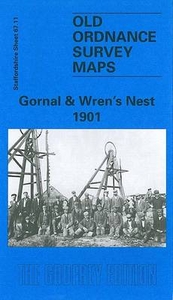
Gornal And Wren`s Nest 1901

Gornal and Wren`s Nest in 1901 in a fascinating series of reproductions of old Ordnance Survey plans in the Alan Godfrey Editions, ideal for anyone interested in the history of their neighbourhood or family. The map covers the north-western part of Dudley including Shavers End and London Fields; coverage continues westward to Lower Gornal, northward to Upper Gornal. Features include Dudley Workhouse, tramways, football ground, Russell`s Hall, Woodsellor`s Farm, Wren`s Nest Hill, Old Priory Farm, London Fields Works, Dibdalebank, Dibdale Works, Graveyard, Dibdale Colliery, Upper Gornal Colliery, Ruiton, brick works, old coal shafts, etc. On the reverse are directories of Upper and Lower Gornal. This title doubles up as Worcestershire sheet 1.11. About the Alan Godfrey
Editions of the 25” OS Series:Selected towns in Great Britain and Ireland are covered by maps showing the extent of urban development in the last decades of the 19th and early 20th century. The plans have been taken from the Ordnance Survey mapping and reprinted at about 15 inches to one mile (1:4, 340). On the reverse most maps have historical notes and many also include extracts from contemporary directories. Most maps cover about one mile (1.6kms) north/south, one and a half miles (2.4kms) across; adjoining sheets can be combined to provide wider coverage.FOR MORE INFORMATION AND A COMPLETE LIST OF ALL AVAILABLE TITLES PLEASE CLICK ON THE SERIES LINK.
RIP - This product is no longer available on our network. It was last seen on 25.09.2019

This page now acts as a permanent archive for this product. Add more information using the comments box below to ensure it can still be found by future generations.

Use our search facility to see if it is available from an alternative contributor.
  • Availability: Out Of Stock
  • Supplier: Stanfords
  • SKU: 9781841510224
Availability: In Stock
£3.50

Product Description

Gornal & Wren`s Nest in 1901 in a fascinating series of reproductions of old Ordnance Survey plans in the Alan Godfrey Editions, ideal for anyone interested in the history of their neighbourhood or family. The map covers the north-western part of Dudley including Shavers End & London Fields; coverage continues westward to Lower Gornal, northward to Upper Gornal. Features include Dudley Workhouse, tramways, football ground, Russell`s Hall, Woodsellor`s Farm, Wren`s Nest Hill, Old Priory Farm, London Fields Works, Dibdalebank, Dibdale Works, Graveyard, Dibdale Colliery, Upper Gornal Colliery, Ruiton, brick works, old coal shafts, etc. On the reverse are directories of Upper & Lower Gornal. This title doubles up as Worcestershire sheet 1.11. About the Alan Godfrey Editions of the 25” OS Series: Selected towns in Great Britain & Ireland are covered by maps showing the extent of urban development in the last decades of the 19th & early 20th century. The plans have been taken from the Ordnance Survey mapping & reprinted at about 15 inches to one mile (1:4, 340). On the reverse most maps have historical notes & many also include extracts from contemporary directories. Most maps cover about one mile (1.6kms) north/south, one & a half miles (2.4kms) across; adjoining sheets can be combined to provide wider coverage.FOR MORE INFORMATION & A COMPLETE LIST OF ALL AVAILABLE TITLES PLEASE CLICK ON THE SERIES LINK.

Reviews/Comments

Add New

Intelligent Comparison

Oooops!
We couldn't find anything!
Perhaps this product's unique.... Or perhaps we are still looking for comparisons!
Click to bump this page and we'll hurry up.

Price History

Vouchers

No voucher codes found.
Do you know a voucher code for this product or supplier? Add it to Insights for others to use.

Facebook

Jargon Buster

Contemporary - Modern era design
Contemporary - A design reference to indicate post war modern design
Football - A sport involving kicking a ball and trying to score a goal
History - Anything that happens in the past. An acedemic subject.
Contemporary - An object that is living in the same time.
Hall - A room at the inside of an entrance of a house.
Ideal - Something that satisfies a perfect criteria.
Family - A group of people that live together made up from parents and children.

Supplier Information

Stanfords
Stanfords was established in 1853 and opened their iconic Covent Garden flagship store in 1901. They have become the top retailer of maps, travel books and accessories in the UK and arguably offer the largest selection of maps and travel books worldwide. Famous names such as Captain Robert Falcon Scott, Ranulph Fiennes and Michael Palin have purchased from Stanfords. They now have a shop in Bristol and both stores together with other venues operate a calendar of events including talks, book signings and exhibitions. As a specialist map retailer, the map selection is comprehensive and includes road maps, street maps and walking maps from worldwide destinations, as well as a selection of world atlases and wall maps. Books include travel guides and travel literature. Stanfords also stock globes, from miniatures made of blue marble to magnificent floor-standing globes. The website features a selection of interesting articles on travel topics.
Page Updated: 2023-11-12 20:15:36

Community Generated Product Tags

Oh No! The productWIKI community hasn't generated any tags for this product yet!
Menu