More From Contributor

£10.99
India at 1:2, 500, 000 on a clear, indexed map from Mair Dumont with a set of removable stickers to highlight chosen locations. A fold-out flap in the jacket makes route planning easier by providing an overview of the whole area covered by the map plus the adjoining regions & highlighting popular locations, with the grid reference system in the margins making it easier to find places on the main map. A set of seven peel-on/peel-off stickers, removable from the map without damaging its surface, is provided for making special locations more prominent. The map covers India, plus the whole of Nepal, Bhutan, Bangladesh & Sri Lanka, with most of Pakistan as well as southern Tibet with Lhasa & Kailas. The north-western tip of the country with the Pakistani part of Jammu & Kashmir & the Karakoram is shown as an inset. Assam & the eastern states are also on an inset which extends the coverage to Mandalay. Two smaller insets show the Andaman & Nicobar Islands. Topography is indicated by relief shading with spot heights & names of mountain & hill ranges & selected peaks. Colouring and/or graphics indicate deserts & marshes. Internal administrative borders are shown with names of the states. The map shows the country’s road & rail networks & highlights numerous towns & villages worth visiting, as well as interesting natural sites, both in India itself & in the adjoining countries. Latitude & longitude lines are marked at intervals of 1º. Multilingual map legend

Includes::
English. Extensive index of place names in all the countries covered by the map is in a separate 48-page booklet attached to the map jacket &

Includes::
names of mountains, glaciers, rivers, lakes, etc. all coded with appropriate signs. Also included are lists of national parks & World Heritage Sites, plus a table with distances/traveling times within India.


...
Archived Product
£45.00
India, its landscape, architectural splendors, people & customs have long been subjects of fascination for photographers. The exquisite images of the photographer Barbara Macklowe thrust us into a world few have seen or think of as India. Yet we can see & feel a familiarity with the people & places in her photographs. We experience both the differences & the sameness among us all. The images in this book are a reflection of one photographer's experience of this diverse land & her attempts to peer beneath the surface to reveal its human dimension. She has an uncanny ability to connect with her subjects. The result is a very personal visual journey which reveals the warmth, beauty & humanity of the Indian people. She reveals a land of beauty, hardship & joy that breathes with life & surges with energy. ...
Archived Product
£11.99
In India in Slow Motion Mark Tully undertakes a journey that has no true beginning or end, seeking to unravel the mysteries lying at the heart of the country of his birth. Exploring subjects such as Hindu extremism, child labour, Sufi mysticism, the crisis in agriculture, political corruption & the problem of Kashmir, he challenges our preconceptions of India as well as those India has about itself to create a thoughtful, humorous, startling & deeply profound portrait of the country. Like no other writer, Mark Tully brings modern India & its people vibrantly to life. With fantastic reviews from Daily Telegraph & Guardian, this book widely known for its vivid picture of India. ...
Archived Product
£16.99
India is like nowhere else on earth
- thrilling, frustrating & incredibly diverse. The full-colour Insight Guide India shows you
...
Archived Product
£9.99
India on an indexed, double-sided map, printed on waterproof & tear-resistant plastic paper, with a street plan of central New Delhi, enlargements for greater Mumbai & Kolkata & a separate index for each side of the map. The map divides India north/south, with Assam & the north-eastern states shown as an inset, & presents the country’s road & rail networks. Local airports are marked. Internal administrative boundaries are shown with names of states given also in Hindi. Given the density of local roads shown on the map, perhaps not as many small town & villages are marked as one would expect. Symbols highlight numerous places of interest, including the country’s historical & architectural treasures, temples & other religious sites, national parks & game reserves, etc. Larger cities are annotated with lists of their main sights. The map has latitude & longitude lines at intervals of 2º & a separate index of localities for each side. Also provided is a street plan of central New Delhi around the Connaught Place, annotated with hotels, restaurants, shops, banks, embassies, governmental offices, etc. Two more insets show the areas of greater Mumbai & Kolkata (Calcutta) with main roads & rail connections. ...
Archived Product
£6.99
Marco Polo India: The Travel Guide with Insider Tips Explore India with Marco Polo! This compact, straightforward guide is clearly structured for ease of use. It gets you right to the heart of this vast country, & provides you with all the latest information & lots of Insider Tips for the ultimate Asian journey.

Includes::
a road atlas & an additional pull-out map, & clear, user-friendly layout. Get your bearings with the ` Where to Start` panels & ensure you don`t miss out on the key sights using the ` Highlights` section The ` Best Of` pages feature unique aspects of the country & also suggest places to go for free, tips for things to do whatever the weather & good places to relax. Insider Tips & much more besides: Marco Polo enables you to fully experience the exotic subcontinent, from the palm-lined waterways of Kerala to the Golden Temple of Amritsar. Find out what other attractions there are apart from the world famous Taj Mahal & the sculptures of the Konark Sun Temple, plus where you can shop at the descendants of the Maharaja of Jaipur`s personal jewellers & enjoy over 600 different species of orchid. With the Marco Polo Excursions & Tours you can explore India along specific routes, & the Low Budget tips help you to save money. The author`s Insider Tips encourage you to see & experience the country in an individual & authentic way. Don`t go on holiday without a Marco Polo guide!

...
Archived Product
£6.95
This mini paperback presents a photographic compilation of modern Indian craft, design & architecture, placed in the context of Indian history & traditions. It looks at the roots & themes of Indian craft & design from village society to Moghul palaces, & shows how these traditional forms are repeated in all the contemporary arts. Herbert Ypma, together with a team of photographers, travelled across India to bring together an array of images of buildings, textiles & ceramics. Together with text, these images provide an insight into the emergence of an aesthetic that truly combines the old with the new. ...
Archived Product
£17.99
India wall map from the National Geographic Society, size 61 x 76cm (24” x 30” approx) – encapsulated version, in the NGS traditional classic style: on a light base with both internal state boundaries & international borders shown in colour. Coverage

Includes::
all of Nepal, Bhutan & Bangladesh, plus most of Tibet, eastern & northern Pakistan, Sri Lanka, etc. Disputed international borders between with Pakistan & China are marked. City names are given in their current version with the historical names in brackets; Kolkata (Calcutta), Varanasi (Banaras), Kochi (Cochin), etc. Topography is indicated by relief shading with names of various mountain ranges, peaks (heights in metres), etc. National parks are highlighted. The map shows the network of main road & rail connections & indicates locations of airports. Latitude & longitude lines are drawn at 4° intervals.* This title is also available on paper without the encapsulation.

...
Archived Product
£12.99
India wall map from the National Geographic Society, size 61 x 76cm (24” x 30” approx) – paper version, in the NGS traditional classic style: on a light base with both internal state boundaries & international borders shown in colour. Coverage

Includes::
all of Nepal, Bhutan & Bangladesh, plus most of Tibet, eastern & northern Pakistan, Sri Lanka, etc. Disputed international borders between with Pakistan & China are marked. City names are given in their current version with the historical names in brackets; Kolkata (Calcutta), Varanasi (Banaras), Kochi (Cochin), etc. Topography is indicated by relief shading with names of various mountain ranges, peaks (heights in metres), etc. National parks are highlighted. The map shows the network of main road & rail connections & indicates locations of airports. Latitude & longitude lines are drawn at 4° intervals.* This title is also available encapsulated.

...
Archived Product
£9.99
Northern & western India on a double-sided, indexed map from ITMB, providing on each side useful coverage of some of the country’s most visited areas. Each side of the map has a separate index of localities. The northern side is centred on Delhi & extends north to the Line of Control dividing Jammu & Kashmir. Coverage east along the Ganges extends beyond Varanasi; west to Jodhour, the outskirts of Ahmadabad & to Vadodara (Baroda); & south to Nagpur, the geographical centre of India. The western side of the map extends from Delhi to Bangalore & Mysore, & inland beyond Hyderabad, so

Includes::
Mumbai & Goa. The map has altitude colouring (in feet) & shows the country’s road & rail networks & local airports. Symbols highlight various places of interest including historic or scenic sites, hill stations, temples & other religious buildings, castles & forts, national parks & wildlife reserves, beaches, boating & rafting facilities, etc. Latitude & longitude lines are drawn at intervals of 2°. Each side of the map has a separate index of place names.

...
Archived Product

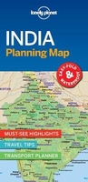
India Lonely Planet Planning Map

With an easy-fold, easy-to-use format, Lonely Planet Planning Maps are your conveniently sized passport to traveling with ease. Get more from your map and your trip with images and information about top country attractions, itinerary suggestions and themed lists.
RIP - This product is no longer available on our network. It was last seen on 25.09.2019

This page now acts as a permanent archive for this product. Add more information using the comments box below to ensure it can still be found by future generations.

Use our search facility to see if it is available from an alternative contributor.
  • Availability: Out Of Stock
  • Supplier: Stanfords
  • SKU: 9781787014572
Availability: In Stock
£4.99

Product Description

With an easy-fold, easy-to-use format, Lonely Planet Planning Maps are your conveniently sized passport to traveling with ease. Get more from your map & your trip with images & information about top country attractions, itinerary suggestions & themed lists.

Reviews/Comments

Add New

Intelligent Comparison

Oooops!
We couldn't find anything!
Perhaps this product's unique.... Or perhaps we are still looking for comparisons!
Click to bump this page and we'll hurry up.

Price History

Vouchers

No voucher codes found.
Do you know a voucher code for this product or supplier? Add it to Insights for others to use.

Facebook

Jargon Buster

India - A subcontinent in Asia

Supplier Information

Stanfords
Stanfords was established in 1853 and opened their iconic Covent Garden flagship store in 1901. They have become the top retailer of maps, travel books and accessories in the UK and arguably offer the largest selection of maps and travel books worldwide. Famous names such as Captain Robert Falcon Scott, Ranulph Fiennes and Michael Palin have purchased from Stanfords. They now have a shop in Bristol and both stores together with other venues operate a calendar of events including talks, book signings and exhibitions. As a specialist map retailer, the map selection is comprehensive and includes road maps, street maps and walking maps from worldwide destinations, as well as a selection of world atlases and wall maps. Books include travel guides and travel literature. Stanfords also stock globes, from miniatures made of blue marble to magnificent floor-standing globes. The website features a selection of interesting articles on travel topics.
Page Updated: 2023-11-12 20:15:36

Community Generated Product Tags

Oh No! The productWIKI community hasn't generated any tags for this product yet!
Menu