
 United Kingdom
 France
 Germany
 Netherlands
 Sweden
 USA
USA
 Italy
Italy
 Spain
Spain
More From Contributor


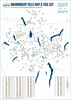
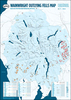
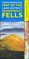
Lake District: Topographical Map Of The Wainwright Fells
The fells of the Lake District shown on a contoured map at 1:100, 000 approx. from Rivers Publishing, with on the reverse side tables showing the 214 fells grouped by location and each presented with its height and a column so the user can record the date climbed or other personal notes. Coverage extends from the Northern Fells group southwards to Windermere and Kendal.On one side a map at 1:100, 000 approx presents the area with contours and bold altitude colouring at intervals of 50m. Each Wainwright summit is clearly marked. Road network indicates locations of car parks; also marked are campsite and caravan sites and youth hostels. The map does not have the lines of the British National Grid.On the reverse a small map indicates how the area is divided into different fell groups and
tables list all the summits in each group, presenting them with heights in metres and a space for personal notes.
tables list all the summits in each group, presenting them with heights in metres and a space for personal notes.

Product Description
Reviews/Comments
Add New
Vouchers
No voucher codes found.
Do you know a voucher code for this product or supplier? Add it to Insights for others to use.
Do you know a voucher code for this product or supplier? Add it to Insights for others to use.
 Denmark