
 United Kingdom
 France
 Germany
 Netherlands
 Sweden
 USA
USA
 Italy
Italy
 Spain
Spain
More From Contributor


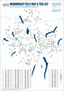


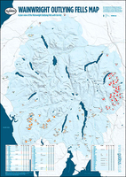
Lake District: Wainwright Outlying Fells With A Tick List Wall Map
The Wainwright Outlying Fells of the Lake District presented on a wall map from GuideUs, size 59.5 x 84cm / 23.5” x 33” approx, each hill is numbered and cross-referenced to a list so that you can tick off the ones you have completed. The map shows the lesser fells around the perimeter of Lake District: north of Cockermouth, east of Ullswater and Haweswater, in the south around Lake Windermere, Coniston Water and Devoke Water, plus in the west north of Calder Bridge.The map shows the whole of the Lake District at 1:90, 000 approx, with names of hills, hill groups, valleys, passes, lakes, major towns and main roads - please note that in the central part only the main peaks are marked. Below the map is a table listing the hills, by group rather than by height, with their
altitudes in metres and feet, as well as Wainwright’s original values and the area of the Lake District the hill is located. Each area is clearly colour-coded both on the map and hill table. The map is printed on high quality 170gsm paper.Please note: GuideUs also publish a similar chart for the Wainwright Fells, available in two different sizes.
altitudes in metres and feet, as well as Wainwright’s original values and the area of the Lake District the hill is located. Each area is clearly colour-coded both on the map and hill table. The map is printed on high quality 170gsm paper.Please note: GuideUs also publish a similar chart for the Wainwright Fells, available in two different sizes.

Product Description
Reviews/Comments
Add New
Vouchers
No voucher codes found.
Do you know a voucher code for this product or supplier? Add it to Insights for others to use.
Do you know a voucher code for this product or supplier? Add it to Insights for others to use.
 Denmark