More From Contributor

£9.99
Lake District in the AA 50 Walks series; comprising an extensive range of walking guides helping you to explore the best walking routes in Great Britain. Each guide covers a total of 50 walks, many of which are circular, between 2-10 miles & also that are suitable for a range of different walking standards. Every walk in the guides has an information box showing clear details of distance, minimum time, level of difficulty, any ascents, the nature of the terrain & landscape, suggested Ordnance Survey map, grid references for starting & finishing points, dog friendliness, parking & any public toilets en route. There are also suggestions of what to look out for & recommended places to eat & drink. Detailed walk descriptions are accompanied by clear mapping of the route ahead, in addition to colour photographs illustrating the highlights of selected routes. ...
Archived Product
£9.99
This guidebook collects the best 30 high fell walks in the Lake District. Every route is graded for difficulty & ranges between 7-23km, &

Includes::
annotated OS maps & variant routes. The walks are divided into 6 sections according to where walkers can start: the Keswick area, Borrowdale & Buttermere, the Western Valleys, Coniston & Langdale, Ambleside, Grasmere & Windermere, or Ullswater. The walks combine Lakeland classics with lesser-known adventures. From classic horseshoes, such as the Newlands Round & the Fairfield Horseshoe, & traditional ascents of England`s most iconic mountains, including its highest peaks Scafell Pike, Scafell, Helvellyn & Skiddaw, to routes onto some of the quieter summits including Gray Crag & Beda Fell, or quieter routes onto popular fells including Blencathra & Red Screes, the walks in this guide comprise all the best high-level fell walks to be had in England`s largest, & beloved National Park. Covering both rocky terrain & grassy hills, with occasional boggy ground, most of the paths are relatively easy-to-follow in clear conditions, but may require good navigational skills when the clouds roll in. The guidebook also

Includes::
information to enhance your walking experience, from historical, geological & wildlife detail, to advice on travelling to & around the Lake District, & how to best prepare for an excellent day out on the fells.


...
Archived Product
£9.99
This guidebook offers 30 delightful but low-level graded day walks in the valleys, beside the lakes & on the low fells of the English Lake District, suitable for walkers of all abilities. Walkers who know the Lakes well may have missed some of the lower gems covered here & the gentler charms of the dales, woodlands & lakeside paths; newcomers will find gentle strolls & straightforward introductions to the lower fells. Highlights featured in this guide include the Borrowdale’s ancient woodl&, Tarn Hows, pretty lakeshore walks, spectacular waterfalls, Hardknott Roman Fort, historic stone circles & breathtaking views everywhere. From delightful wooded glades & sparkling tarns hidden in green folds on the hillside to tumultuous waterfalls & glacier-carved valleys towered over by craggy mountains, this guide aims to seek out the best that the lower areas of the Lake District have to offer. It visits fascinating historical sights, completes circuits of some of the most striking lakes & climbs several smaller fells for breathtaking views. Each route is described step by step with inspiring photographs, OS map extracts & lots of extra information about local history & wildlife. The guide

Includes::
30 of the best low-level walks in the Lake District, over a range of terrain from wide constructed trails to narrow paths on open fell, & stretching from 7 to 17 km, none present technical difficulties.

...
Archived Product
£7.95
The southern fells of the Lake District at 1:25, 000 in a series of handy A5 size Adventure Atlases from Geographers` A-Z Map Company with cartography from the Ordnance Survey’s Explorer series. Coverage

Includes::
Helvellyn, Great Gable, Sca Fell, the Old Man of Coniston, Coniston Water, northern part of Windermere, Haweswater Reservoir, Thirlmere, Buttermere, Ennerdale Water, Wast Water, Grasmere, Ambleside, Troutbeck Bridge, Bowness-on-Windermere, Hawkshead, Clappergate, Coniston, Trover, Satterthwaite, Boot, Santon Bridge, Ennerdale Bridge, Glenridding, Patterdale, etc. To see other titles in this series please click on the series link.A-Z Adventure Atlases have cartography of the Ordnance Survey’s Explorer maps & provide plenty of recreational & tourist information, indicating traditional public rights of way paths, including bridleways & byways restricted or open to motorized traffic. Also shown are other routes with public access, including permissive footpaths & bridleways. Special marking indicates National Trails, Long-distance Routes & Recreational Routes, & for cyclists the maps show traffic-free routes & the National Cycle Network. A wide range of symbols highlights locations of special tourist interest: camping & caravanning sites, youth hostels, information offices & visitors’ centres, parking & picnicking places, historic buildings (indicating where appropriate National Trust, English Heritage, or Cadw), sites for various recreational pursuits, country pubs, public toilets, etc. The mapping provides detailed presentation of the topography with contours at 5 or 10m intervals, numerous spot heights & colouring and/or graphics for different types of terrain or vegetation. Additional colouring shows access l&, including areas managed by the National Trust, Forestry Commission & Woodland Trust. All the standard information expected of high quality survey mapping at this scale is included: finely graded road network, railway lines with stations, cuttings or embankments, individual isolated buildings, etc. For GPS each page as a 1-km British National Grid. Each atlas has an index which

Includes::
geographical features, nature reserves, youth hostels, car parks, etc, & provides additional notes on safety & security when walking, plus QR codes for obtaining by mobile phone information about local weather, danger areas, mountain rescue, map reading, OS National Grid coordinates, etc.


...
Archived Product
£8.95
The fells of the Lake District shown on a contoured map at 1:100, 000 approx. from Rivers Publishing, with on the reverse side tables showing the 214 fells grouped by location & each presented with its height & a column so the user can record the date climbed or other personal notes. Coverage extends from the Northern Fells group southwards to Windermere & Kendal. On one side a map at 1:100, 000 approx presents the area with contours & bold altitude colouring at intervals of 50m. Each Wainwright summit is clearly marked. Road network indicates locations of car parks; also marked are campsite & caravan sites & youth hostels. The map does not have the lines of the British National Grid. On the reverse a small map indicates how the area is divided into different fell groups & tables list all the summits in each group, presenting them with heights in metres & a space for personal notes. ...
Archived Product
£9.99
The Wainwright Fells with a Tick List Wall Map from Guide Us, in a smaller size A2 poster version (42x 59.5cm / 16.5”x 23.5” approx), showing the Wainwright Fells divided into seven areas according to the classic series of guides by Alfred Wainwright: Eastern, Far Eastern, Central, Southern, Northern, North Western & Western Fells. Each area is clearly defined by a different colour & all hills are numbered & cross-referenced to a list of the 214 peaks. This smaller version of the poster shows the Lake District at 1:110, 000, with names of hills, valleys, passes, lakes, major towns & main roads. Coverage extends from the Northern Fell group north of Keswick to the fells around Coniston. Below the map is a table listing all the 214 hills with their altitudes in metres & feet, as well as Wainwright’s original values & their corresponding Wainwright guidebook area. The table also has clear colour-coding showing the area each hill belongs to & a box to tick off each Wainwright fell as it is completed. The poster is printed on high quality 170gsm paper.PLEASE NOTE: this smaller version is also available as a folded map, plus as a poster published in a larger A1 size version at 1:75, 000. Guide Us also publish a chart showing the Wainwright Outlying Fells of the Lake District. ...
Archived Product
£12.99
The Wainwright Outlying Fells of the Lake District presented on a wall map from Guide Us, size 59.5 x 84cm / 23.5” x 33” approx, each hill is numbered & cross-referenced to a list so that you can tick off the ones you have completed. The map shows the lesser fells around the perimeter of Lake District: north of Cockermouth, east of Ullswater & Haweswater, in the south around Lake Windermere, Coniston Water & Devoke Water, plus in the west north of Calder Bridge. The map shows the whole of the Lake District at 1:90, 000 approx, with names of hills, hill groups, valleys, passes, lakes, major towns & main roads
- please note that in the central part only the main peaks are marked. Below the map is a table listing the hills, by group rather than by height, with their altitudes in metres & feet, as well as Wainwright’s original values & the area of the Lake District the hill is located. Each area is clearly colour-coded both on the map & hill table. The map is printed on high quality 170gsm paper. Please note: Guide Us also publish a similar chart for the Wainwright Fells, available in two different sizes.
...
Archived Product
£9.95
Lake Garda & the surrounding area at 1:75, 000 from Litografia Artistica Cartografica in their Globalmap imprint, highlighting five sightseeing routes chosen to present the diversity of its landscape & its sights. Lovely clear cartography makes the road network easy to see, both the selected routes & other local roads & cart tracks. Icons indicate various places of interest & facilities, including tourist information offices, campsites & caravan parks, petrol stations, museums, historical & architectural heritage, sport & recreational sites, etc. On the lake itself ferry routes are marked as well as the direction of its famous thermal winds, including the Ora, Peler, etc. The base map provides an excellent picture of the terrain, with contours enhanced by relief shading, spot heights & names of various peaks, etc. Parco Regionale dell ...
Archived Product
£6.50
Lake Garda & the surrounding area at 1:75, 000 from Litografia Artistica Cartografica in their Globalmap imprint, highlighting five sightseeing routes chosen to present the diversity of its landscape & its sights. Lovely clear cartography makes the road network easy to see, both the selected routes & other local roads & cart tracks. Icons indicate various places of interest & facilities, including tourist information offices, campsites & caravan parks, petrol stations, museums, historical & architectural heritage, sport & recreational sites, etc. On the lake itself ferry routes are marked as well as the direction of its famous thermal winds, including the Ora, Peler, etc. The base map provides an excellent picture of the terrain, with contours enhanced by relief shading, spot heights & names of various peaks, etc. Parco Regionale dell’ Alto Garda & other protected areas as prominently highlighted. For GPS users the map has a UTM grid. Each selected tour has a separate panel listing locations through which it passes with their churches, museums & other places of interest. Map legend & the accompanying text include English. ...
Archived Product
£5.99
Lake Garda & Verona Flexi map is laminated, durable & has its own index that has been categorised for ease of use. Inside Lake Garda & Verona Flexi Map:- A list of recommended sights, divided by theme & linked to the mapping by numbered markers.- A handy information section with concise details on getting around, tourist offices, money, tipping, opening times, public holidays, telephones, emergency telephone numbers & climate.
- The main map shows all one-way streets, car parks, pedestrian zones & public transport routes. About Insight Guides: Insight Guides has over 40 years` experience of publishing high-quality, visual travel guides. We produce around 400 full-colour print guide books & maps as well as picture-packed e Books to meet different travellers` needs. Insight Guides` unique combination of beautiful travel photography & focus on history & culture together create a unique visual reference & planning tool to inspire your next adventure.
...
Archived Product

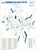
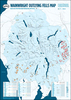
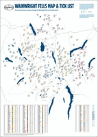
Lake District: Wainwright Fells With A Tick List Wall Map, LARGE (A1)

The Wainwright Fells with a Tick List Wall Map from GuideUs, in a larger size poster version (59.5x84cm / 23.5”x33” approx), showing the Wainwright Fells divided into seven areas according to the classic series of guides by Alfred Wainwright: Eastern, Far Eastern, Central, Southern, Northern, North Western and Western Fells. Each area is clearly defined by a different colour and all hills are numbered and cross-referenced to a list of the 214 peaks.This larger version of the poster shows the Lake District at 1:75, 000, with names of hills, valleys, passes, lakes, major towns and main roads. Coverage extends from the Northern Fell group north of Keswick to the fells around Coniston. Below the map is a table listing all the 214 hills with their altitudes in metres and feet,
as well as Wainwright’s original values and their corresponding Wainwright guidebook area. The table also has clear colour-coding showing the area each hill belongs to and a box to tick off each Wainwright fell as it is completed. The poster is printed on high quality 170gsm paper.PLEASE NOTE: this title is also published in a smaller size version at 1:110, 000 which is available either folded or a poster. GuideUs also publish a chart showing the Wainwright Outlying Fells of the Lake District.
RIP - This product is no longer available on our network. It was last seen on 25.09.2019

This page now acts as a permanent archive for this product. Add more information using the comments box below to ensure it can still be found by future generations.

Use our search facility to see if it is available from an alternative contributor.
  • Availability: Out Of Stock
  • Supplier: Stanfords
  • SKU: 9780993089114
Availability: In Stock
£12.99

Product Description

The Wainwright Fells with a Tick List Wall Map from Guide Us, in a larger size poster version (59.5x 84cm / 23.5”x 33” approx), showing the Wainwright Fells divided into seven areas according to the classic series of guides by Alfred Wainwright: Eastern, Far Eastern, Central, Southern, Northern, North Western & Western Fells. Each area is clearly defined by a different colour & all hills are numbered & cross-referenced to a list of the 214 peaks. This larger version of the poster shows the Lake District at 1:75, 000, with names of hills, valleys, passes, lakes, major towns & main roads. Coverage extends from the Northern Fell group north of Keswick to the fells around Coniston. Below the map is a table listing all the 214 hills with their altitudes in metres & feet, as well as Wainwright’s original values & their corresponding Wainwright guidebook area. The table also has clear colour-coding showing the area each hill belongs to & a box to tick off each Wainwright fell as it is completed. The poster is printed on high quality 170gsm paper.PLEASE NOTE: this title is also published in a smaller size version at 1:110, 000 which is available either folded or a poster. Guide Us also publish a chart showing the Wainwright Outlying Fells of the Lake District.

Reviews/Comments

Add New

Intelligent Comparison

Oooops!
We couldn't find anything!
Perhaps this product's unique.... Or perhaps we are still looking for comparisons!
Click to bump this page and we'll hurry up.

Price History

Vouchers

No voucher codes found.
Do you know a voucher code for this product or supplier? Add it to Insights for others to use.

Facebook

Jargon Buster

Paper - A thin sheet mainly used for writing. Available in a variety of colours. Made mainly from wood pulp.
Metres - A unit of measure, one metre equals 100 centimetres
Wall - A physical barrier between two areas
Colour - The categorised spectrum of light visable to humans
Quality - An object that has quality is superior in function and finish than a less quality object.
Size - is the measurement of how big an object is in space.
Large - something that takes up more space than normal.
Classic - Something that is still like it was originally a high quality standard.
Poster - A printed picture used for decoration or information.
Poster - A large picture usually used for decoration.

Supplier Information

Stanfords
Stanfords was established in 1853 and opened their iconic Covent Garden flagship store in 1901. They have become the top retailer of maps, travel books and accessories in the UK and arguably offer the largest selection of maps and travel books worldwide. Famous names such as Captain Robert Falcon Scott, Ranulph Fiennes and Michael Palin have purchased from Stanfords. They now have a shop in Bristol and both stores together with other venues operate a calendar of events including talks, book signings and exhibitions. As a specialist map retailer, the map selection is comprehensive and includes road maps, street maps and walking maps from worldwide destinations, as well as a selection of world atlases and wall maps. Books include travel guides and travel literature. Stanfords also stock globes, from miniatures made of blue marble to magnificent floor-standing globes. The website features a selection of interesting articles on travel topics.
Page Updated: 2023-11-12 20:15:36

Community Generated Product Tags

Oh No! The productWIKI community hasn't generated any tags for this product yet!
Menu