
 United Kingdom
 France
 Germany
 Netherlands
 Sweden
 USA
USA
 Italy
Italy
 Spain
Spain
More From Contributor


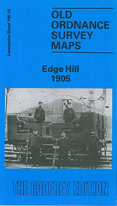
Liverpool Edge Hill 1905
Edge Hill in 1905 in a fascinating series of reproductions of old Ordnance Survey plans in the Alan Godfrey Editions, ideal for anyone interested in the history of their neighbourhood or family. The map covers a major area of east Liverpool, stretching from Grove Street eastward to Wavertree station, and from Edge Lane southward to Rosebery Street. Features include Wavertree Park, Edge Hill station, Spekeland Road Depot, engine shed; numerous junctions, sidings and depots; Botanic Gardens, north end of Toxteth Park Cemetery, Phoenix Safe Works, tramways, bowling greens, coal yards, Mount Vernon Green, Windsor area, Edge Hill area, Wavertree West Ward, Tournament Hall, St Anne`s RC church, Windsor Barracks, St Stephen`s church, St Hugh`s RC church, Edgehill Training
College, St Mary`s church, Confectionery Works, etc. On the reverse are street directory entries for Ashfield, Crown Street, Durning Road, Earle Road and Macdonald Street. About the Alan Godfrey Editions of the 25” OS Series:Selected towns in Great Britain and Ireland are covered by maps showing the extent of urban development in the last decades of the 19th and early 20th century. The plans have been taken from the Ordnance Survey mapping and reprinted at about 15 inches to one mile (1:4, 340). On the reverse most maps have historical notes and many also include extracts from contemporary directories. Most maps cover about one mile (1.6kms) north/south, one and a half miles (2.4kms) across; adjoining sheets can be combined to provide wider coverage.FOR MORE INFORMATION AND A
COMPLETE LIST OF ALL AVAILABLE TITLES PLEASE CLICK ON THE SERIES LINK.

Product Description
Reviews/Comments
Add New
Intelligent Comparison
Archived Product
Liverpool And The Wirral 1904 Stanfords
£3.50
Vouchers
No voucher codes found.
Do you know a voucher code for this product or supplier? Add it to Insights for others to use.
Do you know a voucher code for this product or supplier? Add it to Insights for others to use.
 Denmark