
 United Kingdom
 France
 Germany
 Netherlands
 Sweden
 USA
USA
 Italy
Italy
 Spain
Spain
More From Contributor


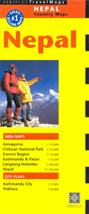
Nepal Periplus Travel Map
Nepal on a double-sided map from Periplus. Includes enlargements of Annapurna, Mount Everest area, Chitwan National Park, Kathmandu and Patan, and Langtang-Helambu. Also includes street plans of Kathmandu City and Pokhara.The map includes:* A general map of the whole country at 1:1, 500, 000, showing main roads, regional airports and national parks. Mountain ranges are named and also provided is light relief shading, mountain passes and spot heights for major peaks. Latitude and longitude lines are drawn at intervals of 1°.* Annapurna region at 1:175, 000, with numerous spot heights, more conspicuous relief shading and showing Annapurna base camp, some trekking routes, information centres, monasteries and temples.* Everest Region at 1:170, 000, showing conspicuous relief
shading, numerous spot heights, some trekking routes, mountain passes and monasteries.* Chitwan National Park (UNESCO World Heritage Site) at 1:350, 000, showing wildlife camps and resorts.* Langtang and Helambu area at 1:200, 000, with greater detail of spot heights, main roads and trekking routes.* Kathmandu and Patan area at 1:55, 500, with major approach roads and numerous places of interest.* Street plans of Pokhara at 1:30, 000 and Kathmandu City at 1:17, 000. These are not indexed, but are annotated with places of interest, temples, bus terminals and numerous restaurants, hotels, etc. Insets provide travel tips and background information for trekking and touring in the country.
shading, numerous spot heights, some trekking routes, mountain passes and monasteries.* Chitwan National Park (UNESCO World Heritage Site) at 1:350, 000, showing wildlife camps and resorts.* Langtang and Helambu area at 1:200, 000, with greater detail of spot heights, main roads and trekking routes.* Kathmandu and Patan area at 1:55, 500, with major approach roads and numerous places of interest.* Street plans of Pokhara at 1:30, 000 and Kathmandu City at 1:17, 000. These are not indexed, but are annotated with places of interest, temples, bus terminals and numerous restaurants, hotels, etc. Insets provide travel tips and background information for trekking and touring in the country.

Product Description
Reviews/Comments
Add New
Intelligent Comparison
Archived Product

Bali Periplus Travel Map Stanfords
£6.99
Archived Product
Laos Periplus Travel Map Stanfords
£6.99
Archived Product
India Periplus Travel Map Stanfords
£6.99
Archived Product

Malaysia Periplus Travel Map Stanfords
£6.99
Archived Product

Thailand Periplus Travel Map Stanfords
£6.99
Archived Product
Indonesia Periplus Travel Map Stanfords
£6.99
Archived Product

Jakarta Periplus Travel Map Stanfords
£6.99
Archived Product
Korea & Seoul Periplus Travel Map Stanfords
£6.99
Vouchers
No voucher codes found.
Do you know a voucher code for this product or supplier? Add it to Insights for others to use.
Do you know a voucher code for this product or supplier? Add it to Insights for others to use.
 Denmark