
 United Kingdom
 France
 Germany
 Netherlands
 Sweden
 USA
USA
 Italy
Italy
 Spain
Spain
More From Contributor

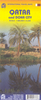


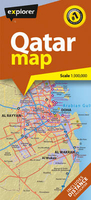
Qatar Country Map
Double-sided, GPS-compatible map from the Dubai-based Explorer Publishing, presenting on one side a road map of Qatar at 1:300, 000 with on the reverse a street plan of Doha at 1:25, 000, with a combined index plus a distance table. All place names are in the Latin alphabet only. On one side is a road map of Qatar, showing the country’s road network including desert tracks with distances on main routes and locations of petrol stations. Various places of interest are highlighted and the map also shows internal administrative division. The map has a 10km UTM grid plus latitude and longitude margin ticks at 30’ intervals. On the reverse is a street plan of Doha at 1:25, 000 with a 2-km UTM grid and coverage including The Pearl Qatar (Al Gassar) area. The plan shows names of
neighbourhoods, plus of main and selected connecting streets. Various facilities and places of interest are named and/or marked by symbols, including hotels and restaurants, banks, embassies and consulates, etc. The accompanying index covers both the road map and the street plan and lists villages, islands, roundabouts and interchanges, hotels and resorts, shopping malls and souks, etc. Also provided is a distance table, with an additional at-a-glance version of it incorporated into the map cover. Map legend and names of facilities are in English.
neighbourhoods, plus of main and selected connecting streets. Various facilities and places of interest are named and/or marked by symbols, including hotels and restaurants, banks, embassies and consulates, etc. The accompanying index covers both the road map and the street plan and lists villages, islands, roundabouts and interchanges, hotels and resorts, shopping malls and souks, etc. Also provided is a distance table, with an additional at-a-glance version of it incorporated into the map cover. Map legend and names of facilities are in English.

Product Description
Reviews/Comments
Add New
Vouchers
No voucher codes found.
Do you know a voucher code for this product or supplier? Add it to Insights for others to use.
Do you know a voucher code for this product or supplier? Add it to Insights for others to use.
 Denmark