More From Contributor

£12.50
A 166km long cycle route from the Hohe Vennen/ Hautes Fagnes National Park in Belgium, along the Rur in Germany, to Roermond in the Netherlands. Detailed maps show the route & its variants & extensive information is conveyed by symbols, indicating road surface, campsites & other accommodation, repair workshops, recreational facilities, places of interest, etc. A list of various types of accommodation facilities is included.IMPORTANT
- PLEASE NOTE: ALL THE TEXT IN THIS TITLE IS GERMAN ONLY. MAP LEGEND

Includes::
ENGLISH, please see our sample image, & the information provided on the maps is sufficient to use this title without any knowledge of German, particularly in the absence of a similar product in English from other publishers. There is currently no English edition this title available in this series. About the series: All the titles have been meticulously researched & are highly regarded in their native Germany. Most titles, as indicated in their individual descriptions, also include a separate section listing selected accommodation, from hotels to campsites, youth hostels & rooms in private houses, all with addresses, telephone numbers & price range. Information on towns along each route

Includes::
a list of places of interest, with opening hours, etc. Several of the guides also have street plans.


...
Archived Product
£15.99
The Rur Ufer Cycle Route, a 172-km long cycle trail from the Hohe Vennen/ Hautes Fagnes National Park in Belgium along the Rur in Germany to the Meuse in the Netherlands, presented by the Verlag Esterbauer in a guide with maps at 1:50, 000 showing the route & its variants. Extensive information is conveyed by symbols, indicating road surface, campsites & other accommodation, repair workshops, recreational facilities, places of interest, etc. A list of various types of accommodation facilities is included.IMPORTANT
- PLEASE NOTE BEFORE ORDERING
- ALL THE TEXT IN THIS TITLE IS GERMAN ONLY. MAP LEGEND

Includes::
ENGLISH (please see our sample image) & the information provided on the maps is sufficient to use this title without any knowledge of German.ABOUT THE BIKELINE SERIES: all the titles have been meticulously researched & are highly regarded in their native Germany. Most titles, as indicated in their individual descriptions, also include a separate section listing selected accommodation, from hotels to campsites, youth hostels & rooms in private houses, all with addresses, telephone numbers & price range. Information on towns along each route

Includes::
a list of places of interest, with opening hours, etc. Several of the guides also have street plans. To see the list of other titles in the Bikeline series please click on the series link.


...
Archived Product
£5.99
Street plan of Ruse at 1:9, 000 from Domino, with an enlargement for the city centre plus on the reverse & extensive English language directory of various services including hotels, restaurants, entertainment, etc. On one side is a street plan of the city with insets extending coverage to the satellite districts, including the crossing point from Romania across the Danube. The plan shows trolleybus & bus routes with stops & line numbers, & is annotated with symbols highlighting locations various facilities. Streets show selected house numbers for easier identification of addresses. An enlargement shows the city centre in greater detail. Names of main streets & districts are also shown in Latin alphabet; street index is in Cyrillic alphabet only. Map legend

Includes::
English. On the reverse is an extensive bilingual directory of various servicies & facilities in the town with notes abut its history & main sights. Also provided is a road map of the surrounding region (place names in Cyrillic), plus a small map of the nearby Rusenski Lom Natural Park.

...
Archived Product
£3.50
Rush Green in 1914 in a fascinating series of reproductions of old Ordnance Survey plans in the Alan Godfrey Editions, ideal for anyone interested in the history of their neighbourhood or family. The map covers the northern part of Dagenham, stretching from Frizlands Lane & the east end of Becontree Heath eastward to the River Rom, & from Rush Green Road southward to Eastbrookend Farm. The area was entirely rural in 1915 & the only notable features are a few farms, some houses at the end of Becontree (Beacontree) Heath, Ilford Park cemetery (now Eastbrookend cemetery) & Romford Isolation Hospital. About the Alan Godfrey Editions of the 25” OS Series: Selected towns in Great Britain & Ireland are covered by maps showing the extent of urban development in the last decades of the 19th & early 20th century. The plans have been taken from the Ordnance Survey mapping & reprinted at about 15 inches to one mile (1:4, 340). On the reverse most maps have historical notes & many also include extracts from contemporary directories. Most maps cover about one mile (1.6kms) north/south, one & a half miles (2.4kms) across; adjoining sheets can be combined to provide wider coverage.FOR MORE INFORMATION & A COMPLETE LIST OF ALL AVAILABLE TITLES PLEASE CLICK ON THE SERIES LINK. ...
Archived Product
£16.99
Each working day 500 million people across the planet experience the miracle & misery of commuting. Whether undertaken by car, bus, train or bicycle, the practice shapes our days & creates a time & a space for a surprisingly diverse range of activities. In RUSH HOUR, Iain Gately traces the past, present & future of commuting, from the age of Dickens to the potential of the driverless car. He examines the contrasting experiences of commuters in Britain & elsewhere in the world: from the crush-loaded salarymen of the Tokyo metro to the road-rage afflicted middle managers of America. Notwithstanding its occasional traumas, commuting emerges as a positive aspect of modern life. It has dictated the growth of cities; been proving ground for new technologies; & given countless people freedom of movement & the opportunity to improve their lives. ...
Archived Product
£14.99
When Mary Davidson, the eldest daughter of a whaling family in Eden, New South Wales, sets out to chronicle the particularly difficult season of 1908, the story she tells is poignant & hilarious, filled with drama & misadventure. It`s a season marked not only by the sparsity of whales & the vagaries of weather, but also by the arrival of John Beck, an itinerant whaleman with a murky past, on whom Mary promptly develops an all-consuming crush. But hers is not the only romance to blossom amidst the blubber.. . Swinging from Mary`s hopes & disappointments, both domestic & romantic, to the challenges that beset their tiny whaling operation, Rush Oh! is a celebration of an extraordinary episode in Australian history when a family of whalers formed a fond, unique alliance with a pod of frisky killer whales
- & in particular, a killer whale named Tom.
...
Archived Product
£2.95
Rushden East in 1923 in a fascinating series of reproductions of old Ordnance Survey plans in the Alan Godfrey Editions, ideal for anyone interested in the history of their neighbourhood or family. Selected towns in Great Britain & Ireland are covered by maps showing the extent of urban development in the last decades of the 19th & early 20th century. In this title: the map covers the eastern part of Rushden, stretching from Rectory Road eastward to High Hayden Lodge. Features include UDC Buildings, Boot & Shoe Factories, Newton Road area, Park Road area, etc. On the reverse is an 1898 commercial directory, entries C-Z. About the Alan Godfrey Editions of the 25 ...
Archived Product
£3.50
Rushden East in 1923 in a fascinating series of reproductions of old Ordnance Survey plans in the Alan Godfrey Editions, ideal for anyone interested in the history of their neighbourhood or family. The map covers the eastern part of Rushden, stretching from Rectory Road eastward to High Hayden Lodge. Features include UDC Buildings, Boot & Shoe Factories, Newton Road area, Park Road area, etc. On the reverse is an 1898 commercial directory, entries C to Z. About the Alan Godfrey Editions of the 25” OS Series: Selected towns in Great Britain & Ireland are covered by maps showing the extent of urban development in the last decades of the 19th & early 20th century. The plans have been taken from the Ordnance Survey mapping & reprinted at about 15 inches to one mile (1:4, 340). On the reverse most maps have historical notes & many also include extracts from contemporary directories. Most maps cover about one mile (1.6kms) north/south, one & a half miles (2.4kms) across; adjoining sheets can be combined to provide wider coverage.FOR MORE INFORMATION & A COMPLETE LIST OF ALL AVAILABLE TITLES PLEASE CLICK ON THE SERIES LINK. ...
Archived Product
£2.95
Rushden West in 1923 in a fascinating series of reproductions of old Ordnance Survey plans in the Alan Godfrey Editions, ideal for anyone interested in the history of their neighbourhood or family. Selected towns in Great Britain & Ireland are covered by maps showing the extent of urban development in the last decades of the 19th & early 20th century. In this title: the map covers the western part of Rushden, stretching from the High Street westward to Knuston Hall. Features include railway station, Irchester Road area, boot & shoe factories, leather dressing works, High Street area, Church Green, Rushden Hall, Home Farm, Royal Theatre, etc. On the reverse is a list of private residents from an 1898 directory, with the commercial entry, entries A-C. About the Alan Godfrey Editions of the 25 ...
Archived Product
£3.50
Rushden West in 1923 in a fascinating series of reproductions of old Ordnance Survey plans in the Alan Godfrey Editions, ideal for anyone interested in the history of their neighbourhood or family. The map covers the western part of Rushden, stretching from the High Street westward to Knuston Hall. Features include railway station, Irchester Road area, boot & shoe factories, leather dressing works, High Street area, Church Green, Rushden Hall, Home Farm, Royal Theatre, etc. On the reverse is a list of private residents from an 1898 directory, with the commercial entry, entries A toC. About the Alan Godfrey Editions of the 25” OS Series: Selected towns in Great Britain & Ireland are covered by maps showing the extent of urban development in the last decades of the 19th & early 20th century. The plans have been taken from the Ordnance Survey mapping & reprinted at about 15 inches to one mile (1:4, 340). On the reverse most maps have historical notes & many also include extracts from contemporary directories. Most maps cover about one mile (1.6kms) north/south, one & a half miles (2.4kms) across; adjoining sheets can be combined to provide wider coverage.FOR MORE INFORMATION & A COMPLETE LIST OF ALL AVAILABLE TITLES PLEASE CLICK ON THE SERIES LINK. ...
Archived Product

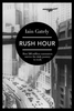
Rush Hour: How 500 Million Commuters Survive The Daily Journey To Work

Each working day 500 million people across the planet experience the miracle and misery of commuting. Whether undertaken by car, bus, train or bicycle, the practice shapes our days and creates a time and a space for a surprisingly diverse range of activities. In RUSH HOUR, Iain Gately traces the past, present and future of commuting, from the age of Dickens to the potential of the driverless car. He examines the contrasting experiences of commuters in Britain and elsewhere in the world: from the crush-loaded salarymen of the Tokyo metro to the road-rage afflicted middle managers of America. Notwithstanding its occasional traumas, commuting emerges as a positive aspect of modern life. It has dictated the growth of cities; been proving ground for new technologies; and given countless
people freedom of movement and the opportunity to improve their lives.
RIP - This product is no longer available on our network. It was last seen on 25.09.2019

This page now acts as a permanent archive for this product. Add more information using the comments box below to ensure it can still be found by future generations.

Use our search facility to see if it is available from an alternative contributor.
  • Availability: Out Of Stock
  • Supplier: Stanfords
  • SKU: 9781781854082
Availability: In Stock
£8.99

Product Description

Each working day 500 million people across the planet experience the miracle & misery of commuting. Whether undertaken by car, bus, train or bicycle, the practice shapes our days & creates a time & a space for a surprisingly diverse range of activities. In RUSH HOUR, Iain Gately traces the past, present & future of commuting, from the age of Dickens to the potential of the driverless car. He examines the contrasting experiences of commuters in Britain & elsewhere in the world: from the crush-loaded salarymen of the Tokyo metro to the road-rage afflicted middle managers of America. Notwithstanding its occasional traumas, commuting emerges as a positive aspect of modern life. It has dictated the growth of cities; been proving ground for new technologies; & given countless people freedom of movement & the opportunity to improve their lives.

Reviews/Comments

Add New

Intelligent Comparison

Oooops!
We couldn't find anything!
Perhaps this product's unique.... Or perhaps we are still looking for comparisons!
Click to bump this page and we'll hurry up.

Price History

Vouchers

No voucher codes found.
Do you know a voucher code for this product or supplier? Add it to Insights for others to use.

Facebook

Jargon Buster

Hour - A measurement of time, 60 minutes is equal to one hour
World - A physical grouping, commonly used to describe earth and everything associated with ti
Car - A machine used for transport which runs on roads
Day - The time it takes a planet or other space objects to complete one rotation.
Road - a manmade lane or a path that is used to speed up travel.
Experience - To gain further knowledge by practising.

Supplier Information

Stanfords
Stanfords was established in 1853 and opened their iconic Covent Garden flagship store in 1901. They have become the top retailer of maps, travel books and accessories in the UK and arguably offer the largest selection of maps and travel books worldwide. Famous names such as Captain Robert Falcon Scott, Ranulph Fiennes and Michael Palin have purchased from Stanfords. They now have a shop in Bristol and both stores together with other venues operate a calendar of events including talks, book signings and exhibitions. As a specialist map retailer, the map selection is comprehensive and includes road maps, street maps and walking maps from worldwide destinations, as well as a selection of world atlases and wall maps. Books include travel guides and travel literature. Stanfords also stock globes, from miniatures made of blue marble to magnificent floor-standing globes. The website features a selection of interesting articles on travel topics.
Page Updated: 2023-11-12 20:15:36

Community Generated Product Tags

Oh No! The productWIKI community hasn't generated any tags for this product yet!
Menu