
 United Kingdom
 France
 Germany
 Netherlands
 Sweden
 USA
USA
 Italy
Italy
 Spain
Spain
More From Contributor

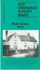

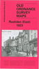


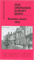
Rushden East 1923
Rushden East in 1923 in a fascinating series of reproductions of old Ordnance Survey plans in the Alan Godfrey Editions, ideal for anyone interested in the history of their neighbourhood or family. Selected towns in Great Britain and Ireland are covered by maps showing the extent of urban development in the last decades of the 19th and early 20th century.In this title: the map covers the eastern part of Rushden, stretching from Rectory Road eastward to High Hayden Lodge. Features include UDC Buildings, Boot & Shoe Factories, Newton Road area, Park Road area, etc. On the reverse is an 1898 commercial directory, entries C-Z. About the Alan Godfrey Editions of the 25
Product Description
Reviews/Comments
Add New
Intelligent Comparison
Archived Product
Rushden East 1923 Stanfords
£3.50
Archived Product
Rushden West 1923 Stanfords
£2.95
Archived Product

Rushden West 1923 Stanfords
£3.50
Archived Product

Rutherglen East 1910 Stanfords
£3.50
Vouchers
No voucher codes found.
Do you know a voucher code for this product or supplier? Add it to Insights for others to use.
Do you know a voucher code for this product or supplier? Add it to Insights for others to use.
 Denmark