
 United Kingdom
 France
 Germany
 Netherlands
 Sweden
 USA
USA
 Italy
Italy
 Spain
Spain
More From Contributor


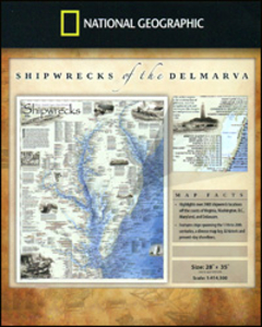
Shipwrecks Of The DelMarVa
Shipwrecks of the DelMarVa DE/MD/VA, a folded map from the National Geographic highlighting over 2400 shipwreck locations off the coast of Virginia, Washington DC, Maryland and Delaware from the 17th to the 20th century. The map shows wrecks along the Atlantic coast of the Delmarva Peninsula, as well as in the Delaware Bay, in the Delaware River up to Philadelphia and the Patapsco River up to Baltimore, in the Chesapeake Bay, along the Potomac up to Washington DC, and in the Rappahannock, York and James Rivers. Information includes lists of vessels scuttled by the Confederate forces during the Civil War.This title is part of a series of shipwreck maps from the NGS covering the coastline of the eastern seaboard of Unites States. Each title shows locations of hundreds of wrecks atop
beautifully drawn bathymetric and coastal detail. Wreck sites have symbols to define class and type of each vessel, along with its name and, where available, the date of sinking. Coloring indicates whether the vessel was lost in armed conflict or by natural causes. The maps also show locations of lighthouses and life boat stations, and include extensive historical notes. This title is also available as a wall map, on paper or encapsulated - please click on the series link for these two options and more titles in this series. With the light blue sea beautifully contrasted against the sepia-coloured land and several lovely historical drawings, these maps are designed to enhance the décor of any home or office and would look very attractive when framed.
beautifully drawn bathymetric and coastal detail. Wreck sites have symbols to define class and type of each vessel, along with its name and, where available, the date of sinking. Coloring indicates whether the vessel was lost in armed conflict or by natural causes. The maps also show locations of lighthouses and life boat stations, and include extensive historical notes. This title is also available as a wall map, on paper or encapsulated - please click on the series link for these two options and more titles in this series. With the light blue sea beautifully contrasted against the sepia-coloured land and several lovely historical drawings, these maps are designed to enhance the décor of any home or office and would look very attractive when framed.

Product Description
Reviews/Comments
Add New
Vouchers
No voucher codes found.
Do you know a voucher code for this product or supplier? Add it to Insights for others to use.
Do you know a voucher code for this product or supplier? Add it to Insights for others to use.
 Denmark