
 United Kingdom
 France
 Germany
 Netherlands
 Sweden
 USA
USA
 Italy
Italy
 Spain
Spain
More From Contributor
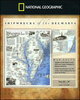

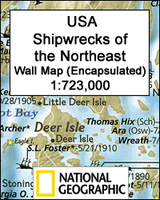
Shipwrecks Of The Northeast USA NGS Wall Map ENCAPSULATED
Shipwrecks of the Northeast USA Wall Map, encapsulated version – size 71 x 91cm (21” x 36”), from the National Geographic highlighting locations of more than 5400 shipwrecks along the coast of New England from the Canadian border to the Napatree Point in Rhode Island. Three panels provide enlargements presenting in greater detail the Boston Harbour area, Cape Cod with Nantucket, and the Narragansett Bay.This title is part of a series of shipwreck maps from the NGS covering the coastline of the eastern seaboard of Unites States. Each title shows locations of hundreds of wrecks atop beautifully drawn bathymetric and coastal detail. Wreck sites have symbols to define class and type of each vessel, along with its name and, where available, the date of sinking. Coloring indicates
whether the vessel was lost in armed conflict or by natural causes. The maps also show locations of lighthouses and life boat stations, and include extensive historical notes. This title is also available on paper without the encapsulation, or as a folded map - please click on the series link for these two options and more titles in this series. With the light blue sea beautifully contrasted against the sepia-coloured land and several lovely historical drawings, these maps are designed to enhance the décor of any home or office and would look very attractive when framed.LAMINATED and ENCAPSULATED WALL MAPS:- LAMINATED wall maps have a thin layer of plastic usually applied to the printed side only. They can be written on with suitable marker pens without any damage to the map but,
unless laminated on both sides, they are not damp-proof.- ENCAPSULATED wall maps are sealed between two sheets of plastic. They are more rigid and heavier than laminated maps of the same size. They are damp-proof and do not crinkle in humid conditions. Encapsulation gives the map a shiny surface, similar to being displayed behind glass.- PLEASE NOTE: many publishers and retailers often use these two terms interchangeably. Our map titles and descriptions follow the definitions provided above.

Product Description
Reviews/Comments
Add New
Vouchers
No voucher codes found.
Do you know a voucher code for this product or supplier? Add it to Insights for others to use.
Do you know a voucher code for this product or supplier? Add it to Insights for others to use.
 Denmark