
 United Kingdom
 France
 Germany
 Netherlands
 Sweden
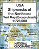
 USA
USA
 Italy
Italy
 Spain
Spain
More From Contributor


Shipwrecks
Introduced by David MitchellIn a coastal village in medieval Japan, a young boy called Isaku battles to keep his family alive against the odds. With his father gone, Isaku is forced to grow up well before his time. He must learn how to catch fish, how to distil salt, and about all the mysteries of the vast churning sea, not least the legend of O-fune-sama, of ships wrecked offshore providing the village with unexpected bounty. When a ship founders on the rocks, Isaku and the villagers rejoice. Long have they prayed for the sea`s gifts. But the cargo is not at all the blessing they had hoped for. At first mystifying, then terrifying, something dark is coming ashore and it`s about to change their lives forever.

Product Description
Reviews/Comments
Add New
Vouchers
No voucher codes found.
Do you know a voucher code for this product or supplier? Add it to Insights for others to use.
Do you know a voucher code for this product or supplier? Add it to Insights for others to use.
 Denmark