
 United Kingdom
 France
 Germany
 Netherlands
 Sweden
 USA
USA
 Italy
Italy
 Spain
Spain
More From Contributor


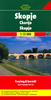


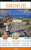

Skopje
Street plan of Skopje at1:18, 000 from the locally based Trimaks, presenting the Macedonian capital with its outer suburbs. On the reverse a large panels shows the city and suburban bus routes, and an enlargement presents the environs of Skopje. Coverage extends west to the exit onto the M1 motorway, north to Radišani and south-east to Dracevo (both shown on insets). The plan indicates main traffic arteries and shows one way streets, car parks and locations of petrol stations. A wide range of symbols indicate various facilities and places of interest, including hotels, banks, shopping malls, embassies, etc. The index is on the reverse. Map legend includes English.On the reverse a large panels presents Skopje with its main streets overprinted with bus lines indicating route
number. Another panel shows a road map of the city’s environs at 1:300, 000.
number. Another panel shows a road map of the city’s environs at 1:300, 000.

Product Description
Reviews/Comments
Add New
Vouchers
No voucher codes found.
Do you know a voucher code for this product or supplier? Add it to Insights for others to use.
Do you know a voucher code for this product or supplier? Add it to Insights for others to use.
 Denmark