More From Contributor

£9.99
Skopelos at 1:25, 000 on a contoured, GPS compatible map published by Terrain Editions, printed on light, waterproof & tear-resistant synthetic paper. Beaches indicate their surface & facilities. All place names are shown in both Greek & Latin alphabet. On the reverse are brief descriptions of seven hiking trails, plus general information about the isl&, illustrated with colour photos. Map legend & all the text include English. Maps of the Greek islands from Terrain Editions have topography well presented by contours at 20m intervals, enhanced by spot heights, subtle relief shading & additional altitude colouring. Road network is very clearly graded according to width & the type of surface, distinguishing between good & rough dirt roads. Distances are marked on most small local roads, as well as locations of petrol stations and/or tyre repair workshops; scenic routes are highlighted. Each map also shows which ports are served by ferry services. Hiking paths are graded as main or narrow trails. National parks & other protected areas are marked & a wide range of symbols indicate various places of interest & recreational facilities, with main sights clearly highlighted. Most titles distinguish between sandy & pebble beaches; some also indicate beaches with natural shade and/or the type of sea bed. The maps have a UTM grid, plus latitude & longitude margin ticks. The reverse side of each title is covered by general information about the isl&, illustrated with colour photos. Many titles also include brief descriptions of recommended hiking trails and/or a street plan of the island’s main town, with colouring clearly showing various tourist facilities. ...
Archived Product
£8.50
Street plan of Skopje at 1:18, 000 from the locally based Trimaks, presenting the Macedonian capital with its outer suburbs. On the reverse a large panels shows the city & suburban bus routes, & an enlargement presents the environs of Skopje. Coverage extends west to the exit onto the M1 motorway, north to Radišani & south-east to Dracevo (both shown on insets). The plan indicates main traffic arteries & shows one way streets, car parks & locations of petrol stations. A wide range of symbols indicate various facilities & places of interest, including hotels, banks, shopping malls, embassies, etc. The index is on the reverse. Map legend

Includes::
English. On the reverse a large panels presents Skopje with its main streets overprinted with bus lines indicating route number. Another panel shows a road map of the city’s environs at 1:300, 000.

...
Archived Product
£9.99
Skopje at 1:15, 000 from Freytag & Berndt in a large indexed street plan covering the city with its outer districts. Principal traffic arteries are highlighted & the city’s main places of interest or local facilities are marked & named. Street index is on the reverse. Multilingual map legend

Includes::
English.

...
Archived Product
£8.50
Skopje’s city centre on both sides of the Vardar River on a lovely street plan from the local publishers Trimaks, with buildings drawn in 3-D vividly presenting the capital’s mixture of old buildings, the communist era architecture, & more recent additions. 68 locations, including museums & cultural institutions, selected embassies & other public buildings, historic sites, etc, are cross-referenced to a thematic index. Symbols indicate locations of restaurants, cafes or bars, & car parks. Street names are in the Latin alphabet. On the reverse numerous sites & institutions have descriptions accompanied by colour photos. Map legend & the text include English. ...
Archived Product
£9.99
Skopje with its outer suburbs in a street atlas at 1:22, 222 approx. from the locally based Trimaks, highlighting locations of various facilities & places of interest, , including hotels, banks, shopping malls, embassies, etc. Streets are shown with their names plus numbers and/or just numbers, & in some districts on housing estates individual buildings have numbers. In the outlaying suburbs only main streets are named. The plan indicates main traffic arteries & shows one way streets, car parks & locations of petrol stations. A wide range of symbols indicate various facilities & places of interest. All place names are in the Latin alphabet. Each page has its individual index, & there is a combined double index at the back of the atlas: alphabetically (but according to the Cyrillic alphabet, a, b, v, g, etc) & by street number. Also provided are lists of useful addresses and/or phone numbers, including selected embassies, hotels, banks, etc., plus a road map of Macedonia for route planning. Map legend

Includes::
English.

...
Archived Product
£19.95
Topographic survey of Faroe Islands at 1:20, 000 prepared by the Danish national mapping agency Kort og Matrikelstyrelsen. The islands’ topography is vividly presented by contours at 5 metre intervals, enhanced by relief shading plus colouring and/or graphics for different types of terrain or vegetation (scree, boulders, etc). The maps show all the detail expected of the topographic mapping at this scale & have a 1-km UTM grid, plus margin ticks for latitude & longitude at 1’ & 2` respectively. Map legend is in Danish only. The maps are available either separately or as sets of five of more sheets, each covering the main island group: Vagar, Sandoy, Suduroy, Nordoyar, Streymoy & Eysturoy. To see the list of all the titles in this series please click on the series link. ...
Archived Product
£16.99
Sverigeserien is an outdoor map series consisting of 116 sheets with coverage of southern & central Sweden & the northern coastline. The map is suitable for outdoor activities such as hiking, excursions, trail running, hunting, fishing, riding, cycling, mountain biking, paddling, skating & much more. Every sheet covers an area of 45x 68km. These topographical maps in scale 1:50 000 contain all the information needed for outdoor activities: Terrain information, hiking trails, illuminated tracks, camping, shelters, golf courses, leisure baths, historical remains, roads in different categories, railway lines & much more. Easy to read topography with contour lines, vertical interval 5 m. Sverigeserien is a high-quality map series & is durable for frequent use! Updated content with map data from Lantmäteriet (National Land Survey of Sweden) & printed on Polyart which is water & tear resistant. This means that the map can be folded repeatedly without breaking & can withstand the challenging weather in Sweden during both winter & summer. Legend is in Swedish, English & German. ...
Archived Product
£9.99
Skrapari Prefecture at 1:100, 000 in a series of handy size, waterproof & tear-resistant, contoured & GPS compatible road maps from the Tirana-based publishers Vektor. Landscape is presented by altitude colouring & contours lines at 100m intervals, with spot heights & a few more names of topographic features than found on Vektor’s 200K road maps of the country. National parks & nature reserves are prominently highlighted. The prefecture maps appear to show the same small local dirt roads as in the 200K series, but given the increase in scale do so with greater clarity & also provide more detailed GPS coordinates (latitude & longitude lines are drawn at 5’ intervals), useful when travelling across the more remote parts of the country. Railway lines are included & local airports are marked. Symbols highlight campsites, beaches, archaeological & historical sites, caves, etc. The maps also show subdivisions of prefectures & names of the communes, & indicate administrative status of towns. Map legend

Includes::
English. Please note: border crossings are prominently marked but beyond topographic colouring no road or other information is provided outside the country’s borders.

...
Archived Product
£23.99
Skrim
- Vindfjell area in Norway in a series of GPS compatible recreational maps at 1:50, 000 with cartography from Norway’s topographic
...
Archived Product
£6.99
Meet the great Skulduggery Pleasant: wise-cracking detective, powerful magician, master of dirty tricks & burglary (in the name of the greater good, of course). Oh yeah. & dead. Then there`s his sidekick, Stephanie. She`s...well, she`s a twelve-year-old girl. With a pair like this on the case, evil had better watch out...” So you won`t keep anything from me again?” He put his hand to his chest. ” Cross my heart & hope to die.” ” Okay then. Though you don`t actually have a heart, ” she said. ”I know.” ” And technically, you`ve already died.” ”I know that too.” ” Just so we`re clear.” Stephanie`s uncle Gordon is a writer of horror fiction. But when he dies & leaves her his estate, Stephanie learns that while he may have written horror, it certainly wasn`t fiction. Pursued by evil forces intent on recovering a mysterious key, Stephanie finds help from an unusual source
- the wisecracking skeleton of a dead wizard. When all hell breaks loose, it`s lucky for Skulduggery that he`s already dead. Though he`s about to discover that being a skeleton doesn`t stop you from being tortured, if the torturer is determined enough. & if there`s anything Skulduggery hates, it`s torture... Will evil win the day? Will Stephanie & Skulduggery stop bickering long enough to stop it? One thing`s for sure: evil won`t know what`s hit it.
...
Archived Product

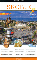
Skopje Tourist Guide

The city of Skopje, from the ancient past to the present, with over 700 photographs, illustrations and maps offering information on the places to visit, where to stay, where to eat. The guide contains a city map showing all the streets and important buildings, as well as an index for easier navigation across the maps. The guide contains all points of interest about Skopje and its beauties, churches and monasteries, mosques, monuments, museums, restaurants and cafes, cinemas, the Fortress Kale, the Millennium Cross and many other famous natural beauties that adorn Skopje. All this is enriched with beautiful photographs and detailed descriptions in Macedonian and English, and maps of the city.
RIP - This product is no longer available on our network. It was last seen on 25.09.2019

This page now acts as a permanent archive for this product. Add more information using the comments box below to ensure it can still be found by future generations.

Use our search facility to see if it is available from an alternative contributor.
  • Availability: Out Of Stock
  • Supplier: Stanfords
  • SKU: 9786082041131
Availability: In Stock
£14.99

Product Description

The city of Skopje, from the ancient past to the present, with over 700 photographs, illustrations & maps offering information on the places to visit, where to stay, where to eat. The guide contains a city map showing all the streets & important buildings, as well as an index for easier navigation across the maps. The guide contains all points of interest about Skopje & its beauties, churches & monasteries, mosques, monuments, museums, restaurants & cafes, cinemas, the Fortress Kale, the Millennium Cross & many other famous natural beauties that adorn Skopje. All this is enriched with beautiful photographs & detailed descriptions in Macedonian & English, & maps of the city.

Reviews/Comments

Add New

Intelligent Comparison

Oooops!
We couldn't find anything!
Perhaps this product's unique.... Or perhaps we are still looking for comparisons!
Click to bump this page and we'll hurry up.

Price History

Vouchers

No voucher codes found.
Do you know a voucher code for this product or supplier? Add it to Insights for others to use.

Facebook

Jargon Buster

Natural - not manmade
illustrations - Pictures typically in books and newspapers.

Supplier Information

Stanfords
Stanfords was established in 1853 and opened their iconic Covent Garden flagship store in 1901. They have become the top retailer of maps, travel books and accessories in the UK and arguably offer the largest selection of maps and travel books worldwide. Famous names such as Captain Robert Falcon Scott, Ranulph Fiennes and Michael Palin have purchased from Stanfords. They now have a shop in Bristol and both stores together with other venues operate a calendar of events including talks, book signings and exhibitions. As a specialist map retailer, the map selection is comprehensive and includes road maps, street maps and walking maps from worldwide destinations, as well as a selection of world atlases and wall maps. Books include travel guides and travel literature. Stanfords also stock globes, from miniatures made of blue marble to magnificent floor-standing globes. The website features a selection of interesting articles on travel topics.
Page Updated: 2023-11-12 20:15:36

Community Generated Product Tags

Oh No! The productWIKI community hasn't generated any tags for this product yet!
Menu