
 United Kingdom
 France
 Germany
 Netherlands
 Sweden
 USA
USA
 Italy
Italy
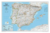
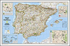
 Spain
Spain
More From Contributor


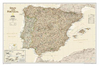

Spain And Portugal In The Reign Of Charles III Wall Map
The Iberian Peninsula on a reproduction of a map published by the Dutch cartographic and engraving firm of Danckerts showing the theatres of regional conflicts during the rule of Charles III who reigned from 1759 to 1788.The map, to give its full title “Accuratissima Totius Regni Hispaniae, Tabula per Iustinium Dancherts – Theatre de la Guerre en Espagne et en Portugal Presente a Charles III, Roy d’Espagne et des Indes, etc, etc”, is surrounded by beautiful engravings, including flotillas of ships, soldiers, etc. The map, reproduced by Spain’s civilian survey organization IGN/CNIG is printed on high quality glossy paper.

Product Description
Reviews/Comments
Add New
Vouchers
No voucher codes found.
Do you know a voucher code for this product or supplier? Add it to Insights for others to use.
Do you know a voucher code for this product or supplier? Add it to Insights for others to use.
 Denmark