More From Contributor

£20.00
Spain an Portugal in 1842 on a colourful, cloth-backed reproduction (small size) from the Old Folding Maps of a map originally published by G.F. Cruchley as part of their enhanced Atlas for Schools & Families. Within Spain regions are presented in different colours; in Portugal the map shows boundaries of the provinces. Hachures indicate mountain ranges & the map shows the names not only of the main rives but also of many smaller ones. Latitude & longitude lines are drawn at 1° intervals. Each individual cloth-backed map is sold folded in a colourful case covered with a unique design marbled paper – no two cases are identical.PLEASE NOTE: to see the list of all the titles in this series from the Old Folding Maps please click on the series link. ...
Archived Product
£5.99
Spain & Portugal at 1:1, 000, 000 from Michelin, with information on driving regulations in each country, plus a distance & journey time table. The index, next to the map, lists locations in the two countries separately. Roads network

Includes::
local roads & is graded according to the number of lanes. Motorways indicate toll routes & junctions show full or partial interchanges. Toll barriers, steep gradients, seasonal restrictions & roads in bad condition are marked; scenic routes are highlighted. Railway lines are not included. Relief shading is used to indicate the topography, with colouring for forested areas. Latitude & longitude lines are drawn at 20

...
Archived Product
£5.99
Spain & Portugal at 1:1, 000, 000 from Michelin, 2012 edition, with information on driving regulations in each country, plus a distance & journey time table. The index, next to the map, lists locations in the two countries separately. Roads network

Includes::
local roads & is graded according to the number of lanes. Motorways indicate toll routes & junctions show full or partial interchanges. Toll barriers, steep gradients, seasonal restrictions & roads in bad condition are marked; scenic routes are highlighted. Railway lines are not included. Relief shading is used to indicate the topography, with colouring for forested areas. Latitude & longitude lines are drawn at 20

...
Archived Product
£13.95
Spain & Portugal Executive Style Wall Map from the National Geographic Society, showing the Iberian Peninsula at 1:1, 803, 000 with current information presented in elegant antique style of muted shades of brown & beige. Within Spain the map shows internal administrative boundaries with names of the provinces. Road & rail networks are presented on a base with relief shading to show the topography, with plenty of names of mountain ranges, etc. In Spain national parks are highlighted. Latitude & longitude lines are drawn at intervals of 1 ...
Archived Product
£9.99
The Iberian Peninsula on a reproduction of a map published by the Dutch cartographic & engraving firm of Danckerts showing the theatres of regional conflicts during the rule of Charles III who reigned from 1759 to 1788. The map, to give its full title “ Accuratissima Totius Regni Hispaniae, Tabula per Iustinium Dancherts – Theatre de la Guerre en Espagne et en Portugal Presente a Charles III, Roy d’ Espagne et des Indes, etc, etc”, is surrounded by beautiful engravings, including flotillas of ships, soldiers, etc. The map, reproduced by Spain’s civilian survey organization IGN/CNIG is printed on high quality glossy paper. ...
Archived Product
£17.99
Spain & Portugal Classic Style Wall Map, size 84 x 56cm (33” x 22” approx)
- encapsulated version, from the National Geographic
...
Archived Product
£12.99
Spain & Portugal Classic Style Wall Map, size 84 x 56cm (33” x 22” approx)
- paper version, from the National Geographic Society,
...
Archived Product
£17.99
Spain & Portugal Executive Style Wall Map, size 84 x 56cm (33” x 22” approx)
- encapsulated version, from the National Geographic
...
Archived Product
£12.99
Spain & Portugal Executive Style Wall Map, size 84 x 56cm (33” x 22” approx)
- paper version, from the National Geographic Society,
...
Archived Product
£4.99
Philip`s Spain & Portugal Road Map shows the countries at a standard scale of 1:1M (1 cm on the map = 10 km on the ground). The map

Includes::
a comprehensive index, plus detailed town plans of Alicante, Barcelona, Lisbon, Madrid & Seville, with tourist information clearly marked. The double-sided map has been specially prepared for long-distance travel, picking out major routes & destinations in bold colours for easy journey planning & route-finding, & is a convenient size for use in a vehicle. The digital mapping gives excellent clarity, showing road networks in exceptional detail for this scale. High-quality travel information

Includes::
a wealth of useful detail marking car ferries, national parks, ski resorts, beaches, cathedrals, castles, ancient monuments, & many other places of interest.


...
Archived Product

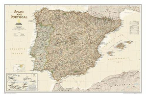
Spain And Portugal NGS Classic Style Wall Map PAPER

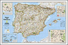
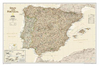
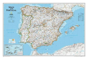
Spain and Portugal Classic Style Wall Map, size 84 x 56cm (33 x 22 approx) - paper version, from the National Geographic Society, showing the Iberian Peninsula at 1:2, 074, 000 with a light base and country boundaries outlined in colour.Within Spain the map shows internal administrative boundaries with names of the regions. Road and rail networks are presented on a base with relief shading to show the topography, with plenty of names of mountain ranges, etc. In Spain national parks are highlighted. Latitude and longitude lines are drawn at intervals of 1
RIP - This product is no longer available on our network. It was last seen on 25.09.2019

This page now acts as a permanent archive for this product. Add more information using the comments box below to ensure it can still be found by future generations.

Use our search facility to see if it is available from an alternative contributor.
  • Availability: Out Of Stock
  • Supplier: Stanfords
  • SKU: 9780792283324
Availability: In Stock
£13.95

Product Description

Spain & Portugal Classic Style Wall Map, size 84 x 56cm (33 x 22 approx)
- paper version, from the National Geographic Society, showing the Iberian Peninsula at 1:2, 074, 000 with a light base & country boundaries outlined in colour. Within Spain the map shows internal administrative boundaries with names of the regions. Road & rail networks are presented on a base with relief shading to show the topography, with plenty of names of mountain ranges, etc. In Spain national parks are highlighted. Latitude & longitude lines are drawn at intervals of 1

Reviews/Comments

Add New

Price History

Vouchers

No voucher codes found.
Do you know a voucher code for this product or supplier? Add it to Insights for others to use.

Facebook

Jargon Buster

Paper - A thin sheet mainly used for writing. Available in a variety of colours. Made mainly from wood pulp.
Spain - A country within the EU.
Wall - A physical barrier between two areas
Colour - The categorised spectrum of light visable to humans
Size - is the measurement of how big an object is in space.
Road - a manmade lane or a path that is used to speed up travel.
Classic - Something that is still like it was originally a high quality standard.

Supplier Information

Stanfords
Stanfords was established in 1853 and opened their iconic Covent Garden flagship store in 1901. They have become the top retailer of maps, travel books and accessories in the UK and arguably offer the largest selection of maps and travel books worldwide. Famous names such as Captain Robert Falcon Scott, Ranulph Fiennes and Michael Palin have purchased from Stanfords. They now have a shop in Bristol and both stores together with other venues operate a calendar of events including talks, book signings and exhibitions. As a specialist map retailer, the map selection is comprehensive and includes road maps, street maps and walking maps from worldwide destinations, as well as a selection of world atlases and wall maps. Books include travel guides and travel literature. Stanfords also stock globes, from miniatures made of blue marble to magnificent floor-standing globes. The website features a selection of interesting articles on travel topics.
Page Updated: 2023-11-12 20:15:36

Community Generated Product Tags

Oh No! The productWIKI community hasn't generated any tags for this product yet!
Menu