
 United Kingdom
 France
 Germany
 Netherlands
 Sweden
 USA
USA
 Italy
Italy
 Spain
Spain
More From Contributor


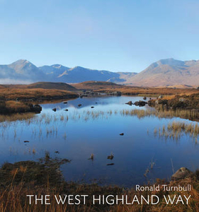
The West Highland Way
The 95-mile West Highland Way was thought out in the 1960s and opened in 1980. But in a sense it has always been here. Clansmen and cattle thieves, redcoats and Sir Walter Scott in quest of a fictional character he called Rob Roy - as well as Rob Roy himself, an honourable cattle thief - have travelled this route between the Lowlands and Lochaber. This book traces the journey of glens and low passes, under the crags and high grassy sides of seven of Scotland`s hill ranges: from the Arrochar Alps of Loch Lomond to the Black Mount of Argyll, the Mamores and Ben Nevis. Along the way we see wild goats, the red deer of Rannoch, the golden eagle, and the meadow pipit. We enjoy purple orchids, wild heather and golden birches and walk through fields of yellow asphodel. Geologically, the
West Highland Way is an outing from the Old Red Sandstone of the so-called Lowland Valley, through the grey schists of the Southern Highlands, to the great volcanic cauldron of Glen Coe. As it unfolds underfoot, it`s an ever-changing vista of heather and oakwood, of lochside and riverside - but also a journey through the whole life and history of Celtic Scotland.
West Highland Way is an outing from the Old Red Sandstone of the so-called Lowland Valley, through the grey schists of the Southern Highlands, to the great volcanic cauldron of Glen Coe. As it unfolds underfoot, it`s an ever-changing vista of heather and oakwood, of lochside and riverside - but also a journey through the whole life and history of Celtic Scotland.

Product Description
Reviews/Comments
Add New
Vouchers
No voucher codes found.
Do you know a voucher code for this product or supplier? Add it to Insights for others to use.
Do you know a voucher code for this product or supplier? Add it to Insights for others to use.
 Denmark