
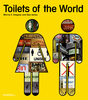
 United Kingdom
 France
 Germany
 Netherlands
 Sweden
 USA
USA
 Italy
Italy
 Spain
Spain
More From Contributor

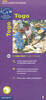


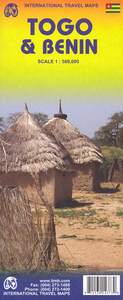
Togo & Benin ITMB
Togo and Benin at 1:580, 000 on a double-sided, indexed road map from ITMB with altitude colouring to show their topography, plus large street plans of the two capital cities, Lomé and Porto Novo annotated with places of interest, etc.The map divides the two countries north/south with a small overlap between the sides. Topography is shown by bold altitude colouring in feet, with spot heights shown mainly in metres. Additional graphics indicate swamps and marshland, as well as areas of seasonal inundation. National parks and forest are highlighted. Road network includes selected local tracks, shows locations of petrol stations and border crossings, and gives driving distances on main and selected secondary routes. Railway lines are included and local airports and air fields are
marked. The map shows internal administrative boundaries (although names of administrative units are not always corresponding to these boundaries). A range of symbols indicate various facilities and places of interest including tourist accommodation, campsites, beaches, golf courses, dispensaries and hospitals, etc. Latitude and longitude lines are drawn at intervals of 1º. Each side of the map has a separate index.Also provided are large insets with street plans of Lomé and Porto Novo. Each plan indicates principal traffic arteries and names main streets and districts. The plans highlight selected hotels and restaurants, embassies, government buildings, rail and bus terminals, etc.
marked. The map shows internal administrative boundaries (although names of administrative units are not always corresponding to these boundaries). A range of symbols indicate various facilities and places of interest including tourist accommodation, campsites, beaches, golf courses, dispensaries and hospitals, etc. Latitude and longitude lines are drawn at intervals of 1º. Each side of the map has a separate index.Also provided are large insets with street plans of Lomé and Porto Novo. Each plan indicates principal traffic arteries and names main streets and districts. The plans highlight selected hotels and restaurants, embassies, government buildings, rail and bus terminals, etc.

Product Description
Reviews/Comments
Add New
Vouchers
No voucher codes found.
Do you know a voucher code for this product or supplier? Add it to Insights for others to use.
Do you know a voucher code for this product or supplier? Add it to Insights for others to use.
 Denmark