
 United Kingdom
 France
 Germany
 Netherlands
 Sweden
 USA
USA
 Italy
Italy
 Spain
Spain
More From Contributor


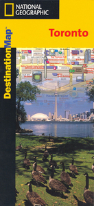
Toronto
Very clear, indexed street mapping of the city including the inner harbour, with an inset showing the Beaches locality. Coverage extends from High Park in the west to Riverdale in the east and from Toronto Islands in the south to The Annex and Rosedale in the north.Toll roads are distinguished and one-way streets, footpaths and cycle paths are indicated. Railways, Metro lines and Streetcar routes and stations/stops are indicated. Colours are used to distinguish between shopping areas, industrial areas, parks, residential complexes, cemeteries and institutional areas. Symbols show the location of police stations, hospitals, hotels, shopping malls, notable buildings, points of interest.A diagram shows the local Metro Streetcar and Commuter Rail network.
Product Description
Reviews/Comments
Add New
Intelligent Comparison
Archived Product
Toronto Stanfords
£8.50
Archived Product
Toronto Stanfords
£6.95
Archived Product
Toronto Stanfords
£4.99
Archived Product
Toronto Stanfords
£10.39
Archived Product
Toronto Stanfords
£36.95
Archived Product
Toronto Stanfords
£6.99
Archived Product
Toronto Noir Stanfords
£12.99
Archived Product

Corongo Stanfords
£29.95
Vouchers
No voucher codes found.
Do you know a voucher code for this product or supplier? Add it to Insights for others to use.
Do you know a voucher code for this product or supplier? Add it to Insights for others to use.
 Denmark