
 United Kingdom
 France
 Germany
 Netherlands
 Sweden
 USA
USA
 Italy
Italy
 Spain
Spain
More From Contributor


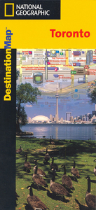
Toronto
The National Geographic map of Toronto at 1:17, 700 is a durable waterproof city map and transport guide designed for tourism. Clear and easy-to-read street mapping has main attractions highlighted and 3D illustrations of top sights. Hotels, churches, theatres and information points are among the tourist features marked on the map. One-way streets and pedestrian areas are indicated. The area covered is from Don Valley and Rosedale in the north to Centre Island in the south, and from Davenport in the west to Greenwood in the east. An enlargement on the reverse shows central Toronto, from Dundas St to the CN tower, at 1:10, 000.The reverse of the map features background information, top sights and activities, basic essential tourist info and city transport network details, as well as
a small map of Lester B Pearson Airport terminals and transport connections. The map is indexed for streets, points of interest and hotels, and includes regional and national overview maps. This map is printed on a surprisingly strong rip-proof, waterproof paper.
a small map of Lester B Pearson Airport terminals and transport connections. The map is indexed for streets, points of interest and hotels, and includes regional and national overview maps. This map is printed on a surprisingly strong rip-proof, waterproof paper.
Product Description
Reviews/Comments
Add New
Intelligent Comparison
Archived Product
Toronto Stanfords
£8.95
Archived Product
Toronto Stanfords
£6.95
Archived Product
Toronto Stanfords
£4.99
Archived Product
Toronto Stanfords
£10.39
Archived Product
Toronto Stanfords
£36.95
Archived Product
Toronto Stanfords
£6.99
Archived Product
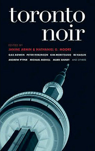
Toronto Noir Stanfords
£12.99
Archived Product

Corongo Stanfords
£29.95
Vouchers
No voucher codes found.
Do you know a voucher code for this product or supplier? Add it to Insights for others to use.
Do you know a voucher code for this product or supplier? Add it to Insights for others to use.
 Denmark