
 United Kingdom
 France
 Germany
 Netherlands
 Sweden
 USA
USA
 Italy
Italy
 Spain
Spain
More From Contributor


Waterloo & Beyond: A Tourist Guide Tothe Battlefield, Museums And
More
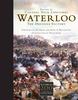
Two hundred years after the battle, the area around Waterloo is a lovely landscape of rolling farmland containing dozens of key sites, memorials and monuments to discover. But the Waterloo region offers far more than just a battlefield. A wealth of sights beckons the curious tourist, including the historic town of Nivelles with its towering Collegiate Church of Saint Gertrude, the exhilarating Walibi theme park at Wavre and the profoundly tranquil ruins of the Abbaye de Villers. Bradt`s Waterloo and Beyond, written by Belgium expert Antony Mason, gives practical advice from the best hotel and restaurant choices to festivals and events throughout the year. This unique tourist guidebook provides everything you`ll need to get the very most from your visit.
Product Description
Reviews/Comments
Add New
Vouchers
No voucher codes found.
Do you know a voucher code for this product or supplier? Add it to Insights for others to use.
Do you know a voucher code for this product or supplier? Add it to Insights for others to use.
 Denmark