
 United Kingdom
 France
 Germany
 Netherlands
 Sweden
 USA
USA
 Italy
Italy
 Spain
Spain
More From Contributor


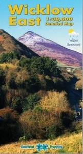
Wicklow Mountains East
Wicklow Mountains East at 1:30, 000 on a detailed GPS compatible map from EastWest Mapping, printed on light, waterproof and tear-resistant paper. Contours at 20m intervals are enhanced by altitude colouring and graphics showing scree, peat bogs, marshland, gorse, different types of woodlands, cultivated areas, etc.The map shows the boundary of the Wicklow Mountains National Park and highlights the Wicklow Way. Hillwalking access points are marked and a note provides information on the rules of public access to the land. Also marked are sighposted cycling trails. A wide range of symbols indicate various places of interest including hotels and campsites, pubs, shops, restaurants, rock climbing and bird watching sites, recreational facilities, historical and geological sites,
etc. The map has a 1km UTM grid and provides a list of useful websites for additional information.To see the other titles in this series please click on the series link.
etc. The map has a 1km UTM grid and provides a list of useful websites for additional information.To see the other titles in this series please click on the series link.

Product Description
Reviews/Comments
Add New
Intelligent Comparison
Archived Product
Wicklow Mountains West Stanfords
£11.99
Vouchers
No voucher codes found.
Do you know a voucher code for this product or supplier? Add it to Insights for others to use.
Do you know a voucher code for this product or supplier? Add it to Insights for others to use.
 Denmark