
 United Kingdom
 France
 Germany
 Netherlands
 Sweden
 USA
USA
 Italy
Italy
 Spain
Spain
More From Contributor

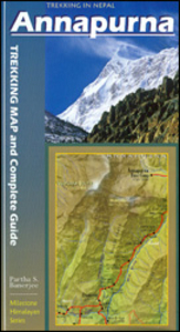
Annapurna Trekking Guide
Annapurna Trekking Guide from Milestone Books with very detailed and informative stage-by-stage descriptions of the Annapurna Circuit and the trek to the Machhaphuchhare and the Annapurna Base Camps. Each route is presented on coloured map extracts from the accompanying separate fold-out map, includes a route profile, and illustrated with numerous colour photos. The description of the Annapurna Circuit includes the spur from Manang to the Tilicho Lake, and the guide also covers shorter treks in the southern part of the region around Ghorepani and Ghandruk.In addition to practical advice and background information about the region, the guide also includes a chapter on the fascinating story of the 1950 epic French ascent of Annapurna I, the first `eight-thousander` ever climbed.The
guide comes with a separate fold-out map of the whole region at 1:125, 000 highlighting the two routes and other local trekking trails (this map is also included as part of the publishers` Annapurna Trekking Atlas).
guide comes with a separate fold-out map of the whole region at 1:125, 000 highlighting the two routes and other local trekking trails (this map is also included as part of the publishers` Annapurna Trekking Atlas).

Product Description
Reviews/Comments
Add New
Vouchers
No voucher codes found.
Do you know a voucher code for this product or supplier? Add it to Insights for others to use.
Do you know a voucher code for this product or supplier? Add it to Insights for others to use.
 Denmark