
 United Kingdom
 France
 Germany
 Netherlands
 Sweden
 USA
USA
 Italy
Italy
 Spain
Spain
More From Contributor


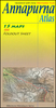
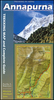
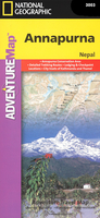
Annapurna Adventure Map
Annapurna area at 1:135, 000 approx. on indexed, light, waterproof and tear-resistant hiking map, with a plan of the Kathmandu/Patan area including an enlargement of the Thamel district, plus an overview map of the whole country.The map is part of a series covering Nepal’s four most popular trekking areas. The maps were prepared by the NGS/Trails Illustrated team responsible for the highly acclaimed hiking maps of national parks in the USA, in cooperation with the Nepa Maps (Himalayan Maphouse), publishers of a wide range of trekking maps of Nepal.Contours (see below) with additional spot heights, relief shading and colouring for glaciers and forested areas present the topography of each area. The maps show settlements, roads and trekking routes, as well as extensive information
for tourists: local airports, lodgings and campsites, numerous places of interest including temples, monasteries, caves, waterfalls, etc. Map ticks at intervals of 1` indicate latitude and longitude. An index of localities includes a list of peaks, passes and lakes. Sherpa spellings are used within the Khumbu area and Nepali spellings elsewhere in the country.On the reverse of each title, a general road map of the whole of Nepal highlights the country’s national parks and nature reserves. Also included is a street plan of Kathmandu with Patan, plus an enlargement for the central Thamel area of the city. The two plans highlight hotels and guesthouses, restaurants, banks, embassies and consulates, places of interest, etc.*In this title:* the map covers the whole of the
Annapurna circuit between Pokhara and Jomoson. Contours are at 100m intervals and all peak heights are also given in metres. Latitude and longitude margin ticks are at 1` intervals. Please note: the cover incorrectly identifies this title as No. 3001 in the series – its correct number is 3003, as shown inside).

Product Description
Reviews/Comments
Add New
Intelligent Comparison
Archived Product
Austria Adventure Map Stanfords
£9.99
Archived Product
Argentina Adventure Map Stanfords
£9.99
Archived Product
Cuba Adventure Map Stanfords
£9.99
Archived Product
China Adventure Map Stanfords
£9.99
Archived Product
India Adventure Map Stanfords
£9.99
Archived Product
Hawaii Adventure Map Stanfords
£9.99
Archived Product
Australia Adventure Map Stanfords
£9.99
Archived Product
Peru Adventure Map Stanfords
£9.99
Vouchers
No voucher codes found.
Do you know a voucher code for this product or supplier? Add it to Insights for others to use.
Do you know a voucher code for this product or supplier? Add it to Insights for others to use.
 Denmark