More From Contributor

£25.00
Antarctica
- Exploring a Fragile Eden is an awesome book reflecting the heart of one of the harshest landscapes on earth. A journey
...
Archived Product
£39.99
Antarctica has, through history, caught the imagination of countless explorers & armchair enthusiasts. It is a continent like no other, encased in ice kilometres thick & virtually uninhabited. This new book covers everything from the history of Antarctic exploration to modern-day life in both Antarctica & the Arctic. Topics include geology, geography, natural history, climate, scientific research & tourism. The authoritative text has been compiled by an expert team of contributors & is complemented by maps & stunning photographs. ...
Archived Product
£9.99
Antarctica & the Arctic presented together on a double-sided map from the British Antarctic Survey at 1:10, 000, 000 in a new edition updated in 2013 (sheets reference BAS Misc: 15A & 15B). One side features a topographic map of the Arctic extending from the North Pole to 60 ...
Archived Product
£9.99
Antarctica & the Arctic presented together at 1:10, 000, 000, each as one side of a double-sided map from the British Antarctic Survey & shown within the circle of 60° of latitude. The newly updated, folded version of this title was published in 2015. On one side is a map of the Antarctic including South Shetland & South Orkney Islands. The map has contour lines at 500m intervals drawn on satellite-based relief shading, plus colouring for rocky outcrops in the coastal areas; also shown is the approximate size of the sub-glacial Lake Vostok. Permanent scientific research stations are marked, plus the UK summer-only stations. For panels in the map corners provide more information: the Southern Ocean within the latitude of 90º south, the sea ice extent & the Antarctic Polar Front, the rock surface beneath the ice sheet, plus size comparison between Antarctica & UK. The map also

Includes::
a list of basic facts about Antarctica: its area with/without ice shelf, different height measurements, plus ice thickness & volume. On the reverse is the Arctic with altitude colouring on the surrounding land masses, plus on Greenland also contours at 500m. Numerous topographic features (mountain ranges, etc) are names, as well as smaller islands off the Russian coast & sea channels in the Arctic part of Canada. The map shows international boundaries, towns, main road & rail connections & airports/airfields. Four additional panels show the extent of permafrost, extent of sea ice, land cover, plus countries in different colours. Also provided are brief notes “ The Arctic & UK Science”. On both maps, the oceans have bathymetric colouring. Latitude & longitude lines are drawn at 5º & 15º respectively. Full BAS reference for this title is “BAS (Misc) 15A & 15B”. This title is also available as a wall map.PLEASE NOTE: to see other BAS maps of wider general interest, please click on the series link. A separate series on our website presents various BAS titles which are of interest mainly to scientific experts or academic staff: larger scale topographic and/or geological/earth sciences maps.

...
Archived Product
£9.99
A double-sided wall from the British Antarctic Survey, size 84x 84cm (33”x 33” approx), presenting Antarctica & the Arctic at 1:10, 000, 000, each as one side of the map & shown within the circle of 60° of latitude. On one side is a map of the Antarctic including South Shetland & South Orkney Islands. The map has contour lines at 500m intervals drawn on satellite-based relief shading, plus colouring for rocky outcrops in the coastal areas; also shown is the approximate size of the sub-glacial Lake Vostok. Permanent scientific research stations are marked, plus the UK summer-only stations. For panels in the map corners provide more information: the Southern Ocean within the latitude of 90º south, the sea ice extent & the Antarctic Polar Front, the rock surface beneath the ice sheet, plus size comparison between Antarctica & UK. The map also

Includes::
a list of basic facts about Antarctica: its area with/without ice shelf, different height measurements, plus ice thickness & volume. On the reverse is the Arctic with altitude colouring on the surrounding land masses, plus on Greenland also contours at 500m. Numerous topographic features (mountain ranges, etc) are names, as well as smaller islands off the Russian coast & sea channels in the Arctic part of Canada. The map shows international boundaries, towns, main road & rail connections & airports/airfields. Four additional panels show the extent of permafrost, extent of sea ice, land cover, plus countries in different colours. Also provided are brief notes “ The Arctic & UK Science”. On both maps, the oceans have bathymetric colouring. Latitude & longitude lines are drawn at 5º & 15º respectively. Full BAS reference for this title is “BAS (Misc) 15A & 15B”. This title is also available as a folded map.PLEASE NOTE: to see other BAS maps of wider general interest, please click on the series link. A separate series on our website presents various BAS titles which are of interest mainly to scientific experts or academic staff: larger scale topographic and/or geological/earth sciences maps.

...
Archived Product
£19.99
Antarctica at 1:7, 000, 000 on a large wall map from Maps International, size 120 x 100cm (3ft 11” x 3ft 4” approx) – paper version, showing topography, territorial claims, research stations, major exploration routes, etc. Coverage is within the latitude of 60°, extending beyond it to include South Georgia & the southern tip of South America. The map presents Antarctica with contour lines, relief shading & plenty of names of various topographic

Features:
mountain ranges, peaks, etc. In the surrounding oceans the extent of the summer & winter ice sheet is shown. Boundaries of different territorial claims are clearly marked, as are locations of scientific bases, indicating those with aircraft or helicopter landing facilities. Also marked are the routes of the four most important expeditions in early 20th century: Scott’s 1902-1903 & 1911-1912, Shackleton’s 1908-1909 & Amundsen’s 1911-1912. Surrounding panels provide more information about various aspects of Antarctica.* This title is also available encapsulated or on hanging strips.

...
Archived Product
£17.99
A wall map with a satellite image of Antarctica,

Size:
79 x 51cm
- encapsulated version, from the National


...
Archived Product
£14.95
A wall map with a satellite image of Antarctica,

Size:
79 x 51cm
- paper version, from the National Geographic


...
Archived Product
£10.50
Antarctica at 1:8, 000, 000 on a folded, waterproof & tear-resistant map from Reise Know-How with plenty of topographic information, prominent highlighting of the continent’s by now numerous research stations, penguin breeding grounds, territorial claims, routes of famous expeditions, etc. The map presents Antarctica’s topography by contours & numerous spot heights, plus plenty of names of mountain ranges, peaks, glaciers, coastal bays, ice shelves, etc. Boundaries of various territorial claims are shown in different colours & locations of permanent or seasonal research stations & encampments are prominently highlighted by national flags; the stations are also annotated with their founding year. The map shows breeding grounds of the emperor & adelie penguins, airstrips & helipads, & the points of southern pole of inaccessibility, South Geomagnetic Pole & the South Magnetic Pole. Expeditions routes marked on the map include those of Amundsen & Scott in 1911, as well as the turning point of Shackleton’s 1909 attempt to reach the South Pole. On the surrounding oceans the map indicates the maximum extent of the sea ices (as measured in September 2012), the maximum extent of pack ice, & the Antarctic Convergence line. Coverage

Includes::
the southern tip of South America & South Georgia. Longitude & latitude lines are drawn at 10° intervals. Multilingual map legend

Includes::
English.


...
Archived Product
£13.95
A large, striking wall map (143x 103cm) derived from remotely sensed data acquired during 1980
- 1987 by the AVHRR sensors on
...
Archived Product

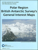
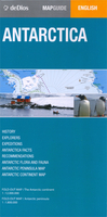
Antarctica De Dios Map-Guide

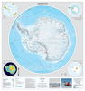
Antarctica on a simple laminated and tear-resistant tourist map with an enlargement for the Antarctic Peninsula, designed to present the basic facts of the continent’s geography and the history of its exploration.On one side is a map of Antarctica with the surrounding ice shelves, bays and seas, indicating main peaks, mountain ranges and regions, plus locations of the scientific stations. The map highlights routes taken by Amundsen and Scott and by two trans-continental expeditions of 1955-58 and 1989-90. A small inset shows regions claimed by various countries.On the reverse is an enlargement of the Antarctic Peninsula and South Shetlands Islands, with more detailed insets showing the Danco Coast with Anvers and Brabant Islands, plus Deception Island. Extensive notes give
biographies of main explorers connected with the region, descriptions of fauna and flora, plus tourist tips. All the text is in English.
RIP - This product is no longer available on our network. It was last seen on 25.09.2019

This page now acts as a permanent archive for this product. Add more information using the comments box below to ensure it can still be found by future generations.

Use our search facility to see if it is available from an alternative contributor.
  • Availability: Out Of Stock
  • Supplier: Stanfords
  • SKU: 9789871551101
Availability: In Stock
£11.99

Product Description

Antarctica on a simple laminated & tear-resistant tourist map with an enlargement for the Antarctic Peninsula, designed to present the basic facts of the continent’s geography & the history of its exploration. On one side is a map of Antarctica with the surrounding ice shelves, bays & seas, indicating main peaks, mountain ranges & regions, plus locations of the scientific stations. The map highlights routes taken by Amundsen & Scott & by two trans-continental expeditions of 1955-58 & 1989-90. A small inset shows regions claimed by various countries. On the reverse is an enlargement of the Antarctic Peninsula & South Shetlands Islands, with more detailed insets showing the Danco Coast with Anvers & Brabant Islands, plus Deception Isl&. Extensive notes give biographies of main explorers connected with the region, descriptions of fauna & flora, plus tourist tips. All the text is in English.

Reviews/Comments

Add New

Intelligent Comparison

Oooops!
We couldn't find anything!
Perhaps this product's unique.... Or perhaps we are still looking for comparisons!
Click to bump this page and we'll hurry up.

Price History

Vouchers

No voucher codes found.
Do you know a voucher code for this product or supplier? Add it to Insights for others to use.

Facebook

Jargon Buster

Ice - Frozen water, the solid state of water.
History - Anything that happens in the past. An acedemic subject.
Small - something that takes up less space than normal.
Ice - Frozen water, Ice is cold to the touch and forms when water reaches 0 degrees centigrade.
Resistant - Something that can repel against something.
Simple - Basic, easy no difficulty in understanding.
Laminated - A thin layer of plastic that gives a coating and shine to a material.

Supplier Information

Stanfords
Stanfords was established in 1853 and opened their iconic Covent Garden flagship store in 1901. They have become the top retailer of maps, travel books and accessories in the UK and arguably offer the largest selection of maps and travel books worldwide. Famous names such as Captain Robert Falcon Scott, Ranulph Fiennes and Michael Palin have purchased from Stanfords. They now have a shop in Bristol and both stores together with other venues operate a calendar of events including talks, book signings and exhibitions. As a specialist map retailer, the map selection is comprehensive and includes road maps, street maps and walking maps from worldwide destinations, as well as a selection of world atlases and wall maps. Books include travel guides and travel literature. Stanfords also stock globes, from miniatures made of blue marble to magnificent floor-standing globes. The website features a selection of interesting articles on travel topics.
Page Updated: 2023-11-12 20:15:36

Community Generated Product Tags

Oh No! The productWIKI community hasn't generated any tags for this product yet!
Menu