
 United Kingdom
 France
 Germany
 Netherlands
 Sweden
 USA
USA
 Italy
Italy
 Spain
Spain
More From Contributor

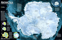
Antarctica NGS Satellite Image Wall Map ENCAPSULATED
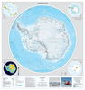
A wall map with a satellite image of Antarctica, size: 79 x 51cm - encapsulated version, from the National Geographic Society, with hill-shading to present the terrain and many peaks, glaciers and research stations. In 1997, in a joint project conducted by the Canadian Space Agency (CSA) and NASA, the satellite Radarsat I imaged the Antarctic in its entirety. The resulting data enabled researchers to fill in the gaps on existing maps. Annotated to briefly present topics such as ice sheet thickness, winds and ice flow velocity. Latitude and longitude lines are overprinted on the map. Projection: Azimuthal Equidistant.*This map is also available on paper without the encapsulation.*LAMINATED and ENCAPSULATED WALL MAPS:*- *laminated* wall maps have a thin layer of plastic usually
applied to the printed side only. They can be written on with suitable marker pens without any damage to the map but, unless laminated on both sides, they are not damp-proof.- *encapsulated* wall maps are sealed between two sheets of plastic. They are more rigid and heavier than laminated maps of the same size. They are damp-proof and do not crinkle in humid conditions. Encapsulation gives the map a shiny surface, similar to being displayed behind glass.- *please note:* many publishers and retailers often use these two terms interchangeably. Our map titles and descriptions follow the definitions provided above.
applied to the printed side only. They can be written on with suitable marker pens without any damage to the map but, unless laminated on both sides, they are not damp-proof.- *encapsulated* wall maps are sealed between two sheets of plastic. They are more rigid and heavier than laminated maps of the same size. They are damp-proof and do not crinkle in humid conditions. Encapsulation gives the map a shiny surface, similar to being displayed behind glass.- *please note:* many publishers and retailers often use these two terms interchangeably. Our map titles and descriptions follow the definitions provided above.

Product Description
Reviews/Comments
Add New
Intelligent Comparison
Archived Product
Antarctica NGS Satellite Image Wall Map PAPER Stanfords
£14.95
Archived Product
Antarctica Satellite Image Wall Map Stanfords
£13.95
Archived Product
World Satellite Image NGS Wall Map ENCAPSULATED Stanfords
£20.99
Archived Product
Africa NGS Executive Wall Map ENCAPSULATED Stanfords
£16.99
Archived Product

Africa NGS Classic Wall Map ENCAPSULATED Stanfords
£17.99
Archived Product
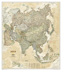
Asia NGS Executive Wall Map ENCAPSULATED Stanfords
£20.99
Archived Product

Australia NGS Classic Wall Map ENCAPSULATED Stanfords
£16.99
Archived Product
Central America NGS Classic Wall Map ENCAPSULATED Stanfords
£17.99
Vouchers
No voucher codes found.
Do you know a voucher code for this product or supplier? Add it to Insights for others to use.
Do you know a voucher code for this product or supplier? Add it to Insights for others to use.
 Denmark