
 United Kingdom
 France
 Germany
 Netherlands
 Sweden
 USA
USA
 Italy
Italy
 Spain
Spain
More From Contributor

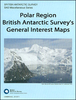
Antarctica Maps International Wall Map PAPER
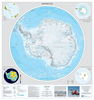
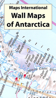
Antarctica at 1:7, 000, 000 on a large wall map from Maps International, size 120 x 100cm (3ft 11” x 3ft 4” approx) – paper version, showing topography, territorial claims, research stations, major exploration routes, etc.Coverage is within the latitude of 60°, extending beyond it to include South Georgia and the southern tip of South America.The map presents Antarctica with contour lines, relief shading and plenty of names of various topographic features: mountain ranges, peaks, etc. In the surrounding oceans the extent of the summer and winter ice sheet is shown. Boundaries of different territorial claims are clearly marked, as are locations of scientific bases, indicating those with aircraft or helicopter landing facilities. Also marked are the routes of the four most
important expeditions in early 20th century: Scott’s 1902-1903 and 1911-1912, Shackleton’s 1908-1909 and Amundsen’s 1911-1912. Surrounding panels provide more information about various aspects of Antarctica.* This title is also available encapsulated or on hanging strips.
important expeditions in early 20th century: Scott’s 1902-1903 and 1911-1912, Shackleton’s 1908-1909 and Amundsen’s 1911-1912. Surrounding panels provide more information about various aspects of Antarctica.* This title is also available encapsulated or on hanging strips.

Product Description
Reviews/Comments
Add New
Vouchers
No voucher codes found.
Do you know a voucher code for this product or supplier? Add it to Insights for others to use.
Do you know a voucher code for this product or supplier? Add it to Insights for others to use.
 Denmark