More From Contributor

£11.99
Antarctica on a simple laminated & tear-resistant tourist map with an enlargement for the Antarctic Peninsula, designed to present the basic facts of the continent’s geography & the history of its exploration. On one side is a map of Antarctica with the surrounding ice shelves, bays & seas, indicating main peaks, mountain ranges & regions, plus locations of the scientific stations. The map highlights routes taken by Amundsen & Scott & by two trans-continental expeditions of 1955-58 & 1989-90. A small inset shows regions claimed by various countries. On the reverse is an enlargement of the Antarctic Peninsula & South Shetlands Islands, with more detailed insets showing the Danco Coast with Anvers & Brabant Islands, plus Deception Isl&. Extensive notes give biographies of main explorers connected with the region, descriptions of fauna & flora, plus tourist tips. All the text is in English. ...
Archived Product
£19.99
Antarctica at 1:7, 000, 000 on a large wall map from Maps International, size 120 x 100cm (3ft 11” x 3ft 4” approx) – paper version, showing topography, territorial claims, research stations, major exploration routes, etc. Coverage is within the latitude of 60°, extending beyond it to include South Georgia & the southern tip of South America. The map presents Antarctica with contour lines, relief shading & plenty of names of various topographic

Features:
mountain ranges, peaks, etc. In the surrounding oceans the extent of the summer & winter ice sheet is shown. Boundaries of different territorial claims are clearly marked, as are locations of scientific bases, indicating those with aircraft or helicopter landing facilities. Also marked are the routes of the four most important expeditions in early 20th century: Scott’s 1902-1903 & 1911-1912, Shackleton’s 1908-1909 & Amundsen’s 1911-1912. Surrounding panels provide more information about various aspects of Antarctica.* This title is also available encapsulated or on hanging strips.

...
Archived Product
£17.99
A wall map with a satellite image of Antarctica,

Size:
79 x 51cm
- encapsulated version, from the National


...
Archived Product
£14.95
A wall map with a satellite image of Antarctica,

Size:
79 x 51cm
- paper version, from the National Geographic


...
Archived Product
£10.50
Antarctica at 1:8, 000, 000 on a folded, waterproof & tear-resistant map from Reise Know-How with plenty of topographic information, prominent highlighting of the continent’s by now numerous research stations, penguin breeding grounds, territorial claims, routes of famous expeditions, etc. The map presents Antarctica’s topography by contours & numerous spot heights, plus plenty of names of mountain ranges, peaks, glaciers, coastal bays, ice shelves, etc. Boundaries of various territorial claims are shown in different colours & locations of permanent or seasonal research stations & encampments are prominently highlighted by national flags; the stations are also annotated with their founding year. The map shows breeding grounds of the emperor & adelie penguins, airstrips & helipads, & the points of southern pole of inaccessibility, South Geomagnetic Pole & the South Magnetic Pole. Expeditions routes marked on the map include those of Amundsen & Scott in 1911, as well as the turning point of Shackleton’s 1909 attempt to reach the South Pole. On the surrounding oceans the map indicates the maximum extent of the sea ices (as measured in September 2012), the maximum extent of pack ice, & the Antarctic Convergence line. Coverage

Includes::
the southern tip of South America & South Georgia. Longitude & latitude lines are drawn at 10° intervals. Multilingual map legend

Includes::
English.


...
Archived Product
£12.79
Antarctica in the unique Wildlife Guide series by Bradt; focusing exclusively on the wildlife of selected regions & countries worldwide, exploring birds, mammals, insects, plants, habitats, geology, conservation, hikes & top bird-watching sites. Each title in the series is an ideal introduction to the wildlife of the destination & an ideal visitors ...
Archived Product
£25.00
For centuries it was suspected that there must be an undiscovered continent in the southern hemisphere. But explorers failed to find one. On his second voyage to the Pacific, Captain Cook sailed further south than any of his rivals but still failed to sight l&. It was not until 1820 that the continent's frozen coast was finally sighted. Territorial rivalry intensified in the 1840s when British, American, & French expeditions sailed south to chart further portions of the continent that had come to be called Antarctica. For the nearly two centuries since, the race to claim exclusive possession of Antarctica has gripped the imagination of the world. Antarctica: A Biography is the first ever major international history of this forbidding continent
- from the eighteenth century voyages of discovery to the fierce rivalries of today, as governments, scientists, environmentalists, & oil companies compete for control. On one level it is the story of explorers battling the elements in the most hostile place on earth as they strive for personal triumph, commercial gain, & national glory. On a deeper level, it is the story of nations seeking to incorporate the Antarctic into their own national stories
- & to claim its frozen wastes as their own.

...
Archived Product
£16.99
Updated throughout, the 6th edition of Bradt's Antarctica: a Guide to Wildlife is the most practical guide to the flora & fauna available for those going south. Celebrating the amazing & often unique species of this spectacular environment, the title features chapters on the region's famous whales & penguins, & also on lesser known species such as skuas & sheathbills, with full coverage of plumage & identification. Each chapter is accompanied by vibrant illustrations from Dafila Scott to help bring species to life. In the last 10 years visitors to Antarctica have trebled to 30, 000, & there are now 35 tour operators visiting the region. Tony Soper's immaculate & engaging text remains the indispensible choice for the intrepid wildlife enthusiast. ...
Archived Product
£9.99
Geological Map of Adelaide Island off the Antarctic Peninsula at 1:200, 000 from the British Antarctic Survey – BAS GEOMAP 2 Series, sheet 2, edition 1, published in 2011. The map

Includes::
a geological cross section from Milestone Bluff to Reptile Ridge.PLEASE NOTE: to see the list of other BAS maps of wider general interest please click on the series link. A separate series on our website presents BAS titles which are of interest mainly to scientific experts or academic staff: larger scale topographic or geological/earth sciences maps of sections of the Antarctic & maps accompanied by detailed booklets/monographs.

...
Archived Product
£19.99
Adelaide Island & the Foyn Coast of the Antarctic Peninsula on a geological map at 1:250, 000 from the British Antarctic Survey. The map is accompanied by a 60-page, A4 illustrated booklet presenting a comprehensive overview of the area’s history, glaciology, geology, etc. BAS ref. for this title is BAS Geomap Sheet 3.PLEASE NOTE: to see the list of other detailed topographic & specialist maps from BAS please click on the series link. BAS maps of wider general interest are listed on our website in a separate series. ...
Archived Product

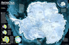
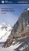
Antarctica Satellite Image Wall Map

A large, striking wall map (143x103cm) derived from remotely sensed data acquired during 1980 - 1987 by the AVHRR sensors on the NOAA 6, 7, 9 and 10 satellites. The images have been corrected and tone-matched to produce this single seamless depiction. Toned in shades of grey/blue, the general relief is portrayed by hill-shading. Major regions, island groups, and sea areas are named, and clouds which could not be eliminated are identified to avoid confusion with terrain features. A polar stereographic graticule of latitude and longitude lines is superimposed over the map, and several national research bases are marked. An inset at 1:17, 500, 000 shows the region in the thermal infrared band, with blue and red tones denoting cooler and warmer areas respectively. A smaller inset map
relates mapped areas to specific satellites and shows the data acquisition times. Explanatory text on the image data and the construction of the image is included.
RIP - This product is no longer available on our network. It was last seen on 25.09.2019

This page now acts as a permanent archive for this product. Add more information using the comments box below to ensure it can still be found by future generations.

Use our search facility to see if it is available from an alternative contributor.
  • Availability: Out Of Stock
  • Supplier: Stanfords
  • SKU: 9780607858884
Availability: In Stock
£13.95

Product Description

A large, striking wall map (143x 103cm) derived from remotely sensed data acquired during 1980
- 1987 by the AVHRR sensors on the NOAA 6, 7, 9 & 10 satellites. The images have been corrected & tone-matched to produce this single seamless depiction. Toned in shades of grey/blue, the general relief is portrayed by hill-shading. Major regions, island groups, & sea areas are named, & clouds which could not be eliminated are identified to avoid confusion with terrain features. A polar stereographic graticule of latitude & longitude lines is superimposed over the map, & several national research bases are marked. An inset at 1:17, 500, 000 shows the region in the thermal infrared b&, with blue & red tones denoting cooler & warmer areas respectively. A smaller inset map relates mapped areas to specific satellites & shows the data acquisition times. Explanatory text on the image data & the construction of the image is included.

Reviews/Comments

Add New

Price History

Vouchers

No voucher codes found.
Do you know a voucher code for this product or supplier? Add it to Insights for others to use.

Facebook

Jargon Buster

Grey - A colour often associated with old age (going grey)
Blue - A primary colour
Wall - A physical barrier between two areas
Red - One of the three primary colours
Large - something that takes up more space than normal.

Supplier Information

Stanfords
Stanfords was established in 1853 and opened their iconic Covent Garden flagship store in 1901. They have become the top retailer of maps, travel books and accessories in the UK and arguably offer the largest selection of maps and travel books worldwide. Famous names such as Captain Robert Falcon Scott, Ranulph Fiennes and Michael Palin have purchased from Stanfords. They now have a shop in Bristol and both stores together with other venues operate a calendar of events including talks, book signings and exhibitions. As a specialist map retailer, the map selection is comprehensive and includes road maps, street maps and walking maps from worldwide destinations, as well as a selection of world atlases and wall maps. Books include travel guides and travel literature. Stanfords also stock globes, from miniatures made of blue marble to magnificent floor-standing globes. The website features a selection of interesting articles on travel topics.
Page Updated: 2023-11-12 20:15:36

Community Generated Product Tags

Oh No! The productWIKI community hasn't generated any tags for this product yet!
Menu