
 United Kingdom
 France
 Germany
 Netherlands
 Sweden
 USA
USA
 Italy
Italy
 Spain
Spain
More From Contributor

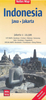

Java - Jakarta F&B
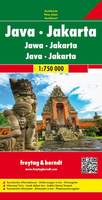
Java with Bali on a double-sided indexed map at 1:750, 000 from Freytag & Berndt, with a street plan of central Jakarta and plans of the Borobudur (Barabudur) and Loro Jonggrang temples. Most place names are in larger print than found on other maps of the island and large icons prominently highlight various places of interest.The map divides Java east/west, with a generous overlap; Semarang and Yogyakarta are included on both sides. Relief shading with names of mountain ranges and spot heights present the topography. Active volcanoes are prominently highlighted. National parks or nature reserves are marked, including the Karimunjawa National Park and the Kepulauan Seribu National Park on the small islands north of Java. The map shows the island’s road network with driving distances on
main routes. Ferry routes are marked, but without indicating their destinations. Icons prominently highlight various places of interest including UNESCO World Heritage sites, other historical and cultural locations, campsites, golf courses, etc. Latitude and longitude lines are drawn at 1º intervals. Multilingual map legend includes English.A large panel provides a street plan of central Jakarta, indicating main traffic arteries and naming selected streets. Also included are plans of the Borobudur (Barabudur) Temple and Loro Jonggrang Temple in the Prambanan Complex.
main routes. Ferry routes are marked, but without indicating their destinations. Icons prominently highlight various places of interest including UNESCO World Heritage sites, other historical and cultural locations, campsites, golf courses, etc. Latitude and longitude lines are drawn at 1º intervals. Multilingual map legend includes English.A large panel provides a street plan of central Jakarta, indicating main traffic arteries and naming selected streets. Also included are plans of the Borobudur (Barabudur) Temple and Loro Jonggrang Temple in the Prambanan Complex.

Product Description
Reviews/Comments
Add New
Vouchers
No voucher codes found.
Do you know a voucher code for this product or supplier? Add it to Insights for others to use.
Do you know a voucher code for this product or supplier? Add it to Insights for others to use.
 Denmark