
 United Kingdom
 France
 Germany
 Netherlands
 Sweden
 USA
USA
 Italy
Italy
 Spain
Spain
More From Contributor


Nepal
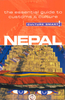
Nepal at 1:950, 000 on an indexed map from the Kathmandu-based Nepa Maps (Himalayan MapHouse) with enlargements presenting in more detail the four most visited areas: Mount Everest, Annapurna, Langtang and Helambu, plus Manaslu and Ganesh.The main map presents the country at 1:950, 000 on a base derived from satellite imagery, with heights of numerous peaks and passes. National parks and conservation areas are highlighted. Road network includes selected local trails; domestic airports are marked. The map also shows the division of the country into regions, with town symbols indicating their administrative status. Symbols highlight various places of interest including UNESCO World heritage sites. The map has latitude and longitude lines at 30’ and is indexed, including lists of
peaks, passes and lakes. The areas beyond Nepal’s borders are blank.The four enlargements provide an excellent, vivid representation of each area’s topography more peak names, highlight main trekking routes, and show campsites and locations with tourist hotels. The regions covered are:- Jiri - Mt Everest region at 1:350, 000 including the whole of the trekking route from Jiri- southern part of the Annapurna Conservation Area at 1:375, 000 with the whole of the Annapurna Circuit, including the spurs to Naar and Phu- Langtang and Helambu region at 1:425, 000 including Kathmandu- the Manaslu – Ganesh area at 1:375, 000 with Besisahar and GorkhaAlso provided are lists of national parks/conservation areas/wildlife reserves, highest peaks, domestic air routes with flight times,
World Heritage sites, a distance table, etc.

Product Description
Reviews/Comments
Add New
Vouchers
No voucher codes found.
Do you know a voucher code for this product or supplier? Add it to Insights for others to use.
Do you know a voucher code for this product or supplier? Add it to Insights for others to use.
 Denmark