-
Home
-
Contributors
-
International
-
Account
-
Information
More From Contributor
- healthy, fresh ingredients used in delicious flavour combinations that are easy to prepare. Try your hand at real Tzatsiki & tasty Dolmades; learn a fuss-free way to prepare grilled meats & seafood; cook up one of Belinda`s warm pies on a cold winter night, & mix a glorious daquiri for a warm summer evening with friends. How many times have you fallen in love with something you have tasted on holiday, only to be disappointed when trying to recreate it at home? Roast Lamb in the Olive Groves not only brings a treasure-trove of tastes home safely, it shows how these dishes can be made dazzling & inspiring for modern cooks to serve at home. In sparkling, original recipes that are true to the spirit of Paxiot cooking, it shows how the ancient can be very modern indeed. ...
Includes:: full explanatory notes & a critical introduction exploring the originality & complexity of Scott`s achievement.ABOUT THE SERIES: For over 100 years Oxford World`s Classics has made available the widest range of literature from around the globe. Each affordable volume reflects Oxford`s commitment to scholarship, providing the most accurate text plus a wealth of other valuable features, including expert introductions by leading authorities, helpful notes to clarify the text, up-to-date bibliographies for further study, & much more. ...
Includes:: route instructions plus a profile showing changes in altitude. The map also provides general information on local public transport, etc. ...
- Robben Island
- a desolate little ...
- & our country truly incredible. ...

Rob Roy Way
indicates various facilities and places of interest. No geographical coordinates for GPS users are provided. The publishers recommend as more detailed and GPS compatible coverage maps of the route from Harvey Map Services or Footprint, or the Explorer Series from the Ordnance Survey (4 maps).To see other titles in this series please click on the series link.
This page now acts as a permanent archive for this product. Add more information using the comments box below to ensure it can still be found by future generations.
Use our search facility to see if it is available from an alternative contributor.
- Availability: Out Of Stock
- Supplier: Stanfords
- SKU: 9781898481478
Product Description
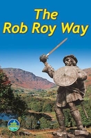
The Rob Roy Way, a 124km/77 miles trail from Drymen near Glasgow to Pitlochry in the Scottish Highlands, presented by Rucksack Readers in handy A5 size, spiral-bound, waterproof guide with mapping at 1:110, 000. The guide provides general advice on when to go, availability of accommodation, etc, &
Includes:: notes on the region’s history, railway heritage, habitats & wildlife, etc. Detailed route descriptions, arranged in daily stages, are preceded by a summary of each section of the route giving distance, terrain, grade, side trips, & availability of food & drink. The guide is illustrated with numerous colour photos. The guide shows the route highlighted on fold-out flap of the cover at 1:110, 000. The map has altitude colouring to show the topography & also indicates various facilities & places of interest. No geographical coordinates for GPS users are provided. The publishers recommend as more detailed & GPS compatible coverage maps of the route from Harvey Map Services or Footprint, or the Explorer Series from the Ordnance Survey (4 maps). To see other titles in this series please click on the series link.
Reviews/Comments
Add New
Intelligent Comparison
We couldn't find anything!
Perhaps this product's unique.... Or perhaps we are still looking for comparisons!
Click to bump this page and we'll hurry up.
Price History
Vouchers
Do you know a voucher code for this product or supplier? Add it to Insights for others to use.


 United Kingdom
 France
 Germany
 Netherlands
 Sweden
 USA
USA
 Italy
Italy
 Spain
Spain


 Denmark