
 United Kingdom
 France
 Germany
 Netherlands
 Sweden
 USA
USA
 Italy
Italy
 Spain
Spain
More From Contributor


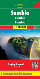
Zambia F&B
Zambia on a large, double-sided map at 1:1, 000, 000 from Freytag & Berndt boldly highlighting its national parks and locations with tourist facilities or places of interest. The map divides the country east-west with a good overlap and its multilingual map legend placed on both sides. The south-eastern part of the Katanga province is included and shown with greater clarity than can be found on most maps of the Democratic Republic of Congo.Topography is shown by relief shading and spot heights, with graphics for swamps, seasonal rivers and lakes, salt flats, etc. National Parks are prominently highlighted. Road network includes cart tracks, shows distances on main routes, and indicates location of border crossings. Railway lines are included, local airports are marked and the map
also shows internal administrative boundaries with names of the provinces. Large icons indicate locations with tourist information services, hotels, lodges, campsites, and various places of interest. The map has latitude and longitude lines are drawn at 1° intervals. Map legend includes English.Also provided is a political map the surrounding part of southern Africa.
also shows internal administrative boundaries with names of the provinces. Large icons indicate locations with tourist information services, hotels, lodges, campsites, and various places of interest. The map has latitude and longitude lines are drawn at 1° intervals. Map legend includes English.Also provided is a political map the surrounding part of southern Africa.

Product Description
Reviews/Comments
Add New
Intelligent Comparison
Archived Product
Namibia F&B Stanfords
£10.99
Archived Product
Zambia ITMB Stanfords
£9.99
Archived Product

Zambia Stanfords
£13.99
Archived Product
Zambia Stanfords
£9.50
Archived Product
Zambia Stanfords
£11.95
Archived Product
Zambia Stanfords
£11.95
Archived Product

Colombia F&B Stanfords
£10.99
Vouchers
No voucher codes found.
Do you know a voucher code for this product or supplier? Add it to Insights for others to use.
Do you know a voucher code for this product or supplier? Add it to Insights for others to use.
 Denmark