More From Contributor

£14.00
An essential new resource for conservationists & birders, this book isn`t just a listing, it is supplemented with excellent quality colour photos & black & white line illustrations of Zambia bird species as well as other fauna. It describes 42 Important Bird Areas identified in Zambia, including 18 National Parks. Each site entry contains a site description, detailed information on the birds & other flora & fauna to be found there, conservation issues & visitor information. There are detailed maps for each site, checklists & the final section contains useful information for visitors including details on health & safety, navigation, transport, & camping. A lengthy introduction gives an overview of Zambian biodiversity & conservation. This is an excellent resource for all those interested in not just Zambian but African avifauna. ...
Archived Product
£18.99
Bradt`s Zambia guidebook offers background information, history, culture & natural history as well as practical guidance, including in-depth reviews of lodges, hotels & campsites. Whilst providing full coverage of the country, this guide concentrates on the places that people really want to visit in Zambia: Zambia`s game-rich safari regions & wildlife areas, along with the Victoria Falls. Also included are GPS coordinates for the small but growing number of self-drive visitors to Zambia, plus information on walking safaris & activities at Victoria Falls & on the Zambezi. ...
Archived Product
£10.99
Zambia on a large, double-sided map at 1:1, 000, 000 from Freytag & Berndt boldly highlighting its national parks & locations with tourist facilities or places of interest. The map divides the country east-west with a good overlap & its multilingual map legend placed on both sides. The south-eastern part of the Katanga province is included & shown with greater clarity than can be found on most maps of the Democratic Republic of Congo. Topography is shown by relief shading & spot heights, with graphics for swamps, seasonal rivers & lakes, salt flats, etc. National Parks are prominently highlighted. Road network

Includes::
cart tracks, shows distances on main routes, & indicates location of border crossings. Railway lines are included, local airports are marked & the map also shows internal administrative boundaries with names of the provinces. Large icons indicate locations with tourist information services, hotels, lodges, campsites, & various places of interest. The map has latitude & longitude lines are drawn at 1° intervals. Map legend

Includes::
English. Also provided is a political map the surrounding part of southern Africa.


...
Archived Product
£9.99
Indexed road map of Zambia with street plans of central Lusaka & Livingstone. Altitude colouring with elevation in feet shows the topography, indicating wetlands & swamp areas. The map shows the country’s rail & road networks, with driving distances on main routes & locations of fuel supplies. National parks are prominently marked & symbols highlight locations with tourist accommodation, campsites, various places of interest, archaeological sites, local airfields, etc. The map is indexed & has a latitude/longitude grid at intervals of 1º. Street plans of central areas of Lusaka & Livingstone show various public buildings, selected accommodation, rail & bus terminals, embassies, etc. ...
Archived Product
£10.99
Zambia on an indexed road map at 1:1, 650, 000 from the South African publishers Map Studio with the road network annotated with locations of filling stations & GPS waypoints for selected junctions, plus a large inset with a street plan of central Lusaka. Satellite derived map base has altitude colouring to show the topography & indicates perennial & seasonal rivers & lakes, as well as boundaries of national parks & game reserves. Road network distinguishes between tarred & unsufaced roads,

Includes::
selected country tracks, & shows border crossings, locations of petrol stations & driving distances on main routes. Several villages and/or road junctions are annotated with their GPS coordinates. Railway lines are included & local airports or airfields are marked. Symbols indicate locations with tourist accommodation, medical facilities & places of interest. The map has latitude & longitude lines at 1° intervals. The index is next to the map. An inset provides a street plan of central Lusaka showing various institutions including embassies, bus terminals, markets, etc.

...
Archived Product
£11.99
Zambia at 1:1, 500, 000 from Hupe Verlag on a very clear map annotated with 413 GPS waypoints & 42 bird watching locations, plus several enlargements for most visited regions of the country annotated with GPS coordinates & street plans of Lusaka & Livingstone. The main map has altitude colouring with spot heights to show the topography, plus graphics for swamps or marshes, wetlands & areas liable to flooding. Numerous rivers are named & national parks are highlighted, with 42 important bird watching areas cross-referenced to a list of their names. Road network distinguishes between tarred & unsurfaced roads &

Includes::
seasonal tracks. Driving distances are given on main roads & locations of petrol stations, entry gates to national parks & border crossings are marked. Railway lines & ferry connections across the lakes are also included. Symbols indicate missions, campsites & various places of interest. 413 locations on the map: important road junctions, lodges & camps, natural features, etc, are cross-referenced to a list of their GPS waypoints. Latitude & longitude lines are drawn at intervals of 1°. Next to the map & on the reverse are enlargements showing the country’s most visited areas in greater detail & with further GPS waypoints, tourist accommodation plus facilities & places of interest: the Luangwa Valley with additional enlargements for the North Luangwa National Park & the Mfuwe area, the Kafue National Park with additional enlargements for the Lufupa & the Itezhi-Tezhi areas, Mosi oa Tunya National Park, & Kasanka National Park. Large panels provide street plans of central Lusaka & Livingstone, each annotated with various facilities, including selected hotels, & places of interest. Two more panels show an overview of Lusaka’s main roads, plus the Livingstone – Victoria Falls area indicating campsites. Also provided is a distance table. All the text is in English.

...
Archived Product
£9.99
If I didn`t define myself for myself, I would be crunched into other people`s fantasies for me & eaten alive.A little black girl opens her eyes in 1930s Harlem. Around her, a heady swirl of passers-by, car horns, kerosene lamps, the stock market falling, fried bananas, tales of her parents` native Grenada. She trudges to public school along snowy sidewalks, & finds she is tongue-tied, legally blind, left behind by her older sisters. On she stumbles through teenage hardships -- suicide, abortion, hunger, a Christmas spent alone -- until she emerges into happiness: an oasis of friendship in Washington Heights, an affair in a dirty factory in Connecticut, &, finally, a journey down to the heat of Mexico, discovering sex, tenderness, & suppers of hot tamales & cold milk. This is Audre Lorde`s story. It is a rapturous, life-affirming tale of independence, love, work, strength, sexuality & change, rich with poetry & fierce emotional power. ...
Archived Product
£9.99
Contoured, GPS-compatible, indexed road map at 1:200, 000 from CNIG
- Spain’s civilian survey organization, with exceptionally
...
Archived Product
£7.95
Zamora on an indexed street plan at 1:6, 000 from Editorial Everest with locations of seven selected hotels. On the reverse is an indexed road map of the Zamora Province at 1:300, 000 highlighting places of interest, plus indexed street plans of Toro (1:7, 000, three hotels) & Benavente (1:12, 000, four hotels). Street plans of Spanish cities from Editorial Everest cover each location with its outer suburbs &, where useful, also presenting a more detailed enlargement for the town ...
Archived Product
£11.99
Topographical survey of Belgium at 1:20, 000 from Nationaal Geografisch Instituut / Institut Géographique National, the country’s national survey organization. Each 20K map covers one quarter of the corresponding 1:50, 000 map (with adjustments in the border & coastal areas). The maps provide all the information expected of topographic mapping at this scale & in addition have an unusually large amount of vegetation and/or land use information (different types of woodlands, gardens, orchards, heath, etc). The maps have a 1-km UTM grid, with margin ticks for latitude & longitude at intervals of 1`. Map legend & a glossary of terms used on the maps include English. Stanfords keeps as regular stock 20K maps for the World War I battlefields around the Ypres, Messines & Passchendaele, & for the area of the Battle of Waterloo. The 1:20, 000 survey covers the whole of Belgium & maps for other regions can be supplied as special orders. To see the list of titles in this series please click on the series link.PLEASE NOTE: the Long-Distance Footpaths Map of Belgium at 1:300, 000 which shows the division of Belgium into the 50K survey sheets can also be used to see in more detail coverage by the 20K maps. ...
Archived Product

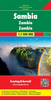
Zambia Reise Know-How

Indexed, waterproof and tear-resistant road map Zambia with topographic and tourist information, published by Reise Know-How as part of their highly acclaimed World Mapping Project. The map is double-sided to provide the best balance between a good scale and a convenient size sheet.Topography is indicated by altitude colouring with numerous spot heights, names of mountain ranges and passes, salt pans, marshes and swamps. Road information includes seasonal tracks and indicates intermediate driving distances on main and secondary roads. Locations of petrol stations, veterinary cordon fences and border crossings are also marked. Other transport details include railways, local airfields, and ferry routes. Internal administrative boundaries are shown with names of the provinces.
National parks and protected areas are marked and symbols highlight various places of interest: UNESCO world heritage sites, archaeological remains, viewpoints, hot springs and wells, caves and rock paintings, selected accommodation including campsites and lodges, medical facilities, etc. The map has a latitude and longitude grid at intervals of 30’ and an index of localities with a separate list of national parks and reserves. Map legend includes English.
RIP - This product is no longer available on our network. It was last seen on 25.09.2019

This page now acts as a permanent archive for this product. Add more information using the comments box below to ensure it can still be found by future generations.

Use our search facility to see if it is available from an alternative contributor.
  • Availability: Out Of Stock
  • Supplier: Stanfords
  • SKU: 9783831773909
Availability: In Stock
£11.50

Product Description

Indexed, waterproof & tear-resistant road map Zambia with topographic & tourist information, published by Reise Know-How as part of their highly acclaimed World Mapping Project. The map is double-sided to provide the best balance between a good scale & a convenient size sheet. Topography is indicated by altitude colouring with numerous spot heights, names of mountain ranges & passes, salt pans, marshes & swamps. Road information

Includes::
seasonal tracks & indicates intermediate driving distances on main & secondary roads. Locations of petrol stations, veterinary cordon fences & border crossings are also marked. Other transport details include railways, local airfields, & ferry routes. Internal administrative boundaries are shown with names of the provinces. National parks & protected areas are marked & symbols highlight various places of interest: UNESCO world heritage sites, archaeological remains, viewpoints, hot springs & wells, caves & rock paintings, selected accommodation including campsites & lodges, medical facilities, etc. The map has a latitude & longitude grid at intervals of 30’ & an index of localities with a separate list of national parks & reserves. Map legend

Includes::
English.

Reviews/Comments

Add New

Intelligent Comparison

Oooops!
We couldn't find anything!
Perhaps this product's unique.... Or perhaps we are still looking for comparisons!
Click to bump this page and we'll hurry up.

Price History

Vouchers

No voucher codes found.
Do you know a voucher code for this product or supplier? Add it to Insights for others to use.

Facebook

Jargon Buster

hot - An indication of the temperature being high and a sensation of heat to the tough
Waterproof - Resistant to water, usualy specified by depth in metres
Railways - A set of tracks that have been laid for the purpose of trains to travel up and down them
World - A physical grouping, commonly used to describe earth and everything associated with ti
Size - is the measurement of how big an object is in space.
Road - a manmade lane or a path that is used to speed up travel.
Resistant - Something that can repel against something.
Altitude - Something that can be quite high in relation to sea or ground level.
Balance - Something that is evenly weighted to keep something upright.
Accommodation - A room in which someone can live in, for example in a hotel
Veterinary - A person who is specialist in medicating and treating animals.
Transport - Something that carries people or goods.
Convenient - Something that suits and fits well to other activities.

Supplier Information

Stanfords
Stanfords was established in 1853 and opened their iconic Covent Garden flagship store in 1901. They have become the top retailer of maps, travel books and accessories in the UK and arguably offer the largest selection of maps and travel books worldwide. Famous names such as Captain Robert Falcon Scott, Ranulph Fiennes and Michael Palin have purchased from Stanfords. They now have a shop in Bristol and both stores together with other venues operate a calendar of events including talks, book signings and exhibitions. As a specialist map retailer, the map selection is comprehensive and includes road maps, street maps and walking maps from worldwide destinations, as well as a selection of world atlases and wall maps. Books include travel guides and travel literature. Stanfords also stock globes, from miniatures made of blue marble to magnificent floor-standing globes. The website features a selection of interesting articles on travel topics.
Page Updated: 2023-11-12 20:15:36

Community Generated Product Tags

Oh No! The productWIKI community hasn't generated any tags for this product yet!
Menu