More From Contributor

£14.39
Zambia & Malawi in the Countries & Regions series from Lonely Planet, market-leading comprehensive guides aimed at independent travellers & serving a large range of international destinations. Frank & informal in style, the guides explore an extensive range of sights, activities, accommodation, restaurants & nightlife & are designed for practical use while travelling on the road. Written & researched by a team of experts, each book is independent in its recommendations & suggestions, often offering individual takes on individual destinations. Widely recognised for their reliability, each Lonely Planet country & region guide has the same layout. Introductory sections profile the destination with individual chapters on particular highlights, getting started, (including when to go) itineraries, history, culture, arts, food & drink & the environment. Each guide is organised geographically by region, with individual sections detailing an extensive range of sights, places of interest, attractions, restaurants, nightlife, accommodation & any local activities. The guides have detailed explanations of historical context where relevant. There is also practical guidance on ...
Archived Product
£17.99
Zambia & Malawi in the Countries & Regions series from Lonely Planet, market-leading comprehensive guides aimed at independent travellers & serving a large range of international destinations. Frank & informal in style, the guides explore an extensive range of sights, activities, accommodation, restaurants & nightlife & are designed for practical use while travelling on the road. Written & researched by a team of experts, each book is independent in its recommendations & suggestions, often offering individual takes on individual destinations. Widely recognised for their reliability, each Lonely Planet country & region guide has the same layout. Introductory sections profile the destination with individual chapters on particular highlights, getting started, (including when to go) itineraries, history, culture, arts, food & drink & the environment. Each guide is organised geographically by region, with individual sections detailing an extensive range of sights, places of interest, attractions, restaurants, nightlife, accommodation & any local activities. The guides have detailed explanations of historical context where relevant. There is also practical guidance on ...
Archived Product
£5.99
. The Globetrotter Travel Map of Zambia & Victoria Falls caters specifically for the needs of tourists who are new to a destination. The town plans of the major centres pinpoint key buildings & places of interest as well as where to stay. Distance & climate charts enable travellers to plan their visits in advance. ...
Archived Product
£9.99
Zambia & Victoria Falls in New Holland’s Globetrotter Travel Guide series, comprising a range of practical & accessible guides to a number of cities, regions & countries worldwide. Globetrotter guides incorporate essential information in an easy-to-carry & easy-to-reference format. They provide visitors with an introduction highlighting the country’s ‘must see’ areas, allowing readers to make the most of their time away. Presented in a paperback PVC format, each guide in the series provides vital tips for visitors &

Includes::
information on the best places to stay, eat & shop, star-rated top attractions, detailed regional profiles & recommendations of the best tours & excursions. Individual titles also have a separate, pull-out overview map in the rear pocket of the guide that serves as a companion to the book itself. An introductory section profiles the destination with details of the l&, a brief history, government & economy & the people. Every chapter is summarised in the ‘ At-a-Glance’ sections at the end of each chapter. There is also a Travel Tips section at the back of each guide providing practical guidance & information on tourist information services, entry requirements, customs, health requirements, getting there, what to pack, money matters, accommodation, transport, business hours, time difference, electricity, health precautions, useful phrases, personal safety, emergencies, etiquette & tipping.

...
Archived Product
£7.99
More than an overview of the colorful sights & sounds, these easy-to-follow chapters paint a vivid picture of the psyche of a people who have been shaped by their geography & history, & who are notable for their warmth, outgoing nature, & zest for life. In this large, landlocked country named after the mighty Zambezi River, the ”real Africa” of old mixes comfortably with the new. Mineral-rich, with vast untapped agricultural, water, energy, & human potential, Zambia sits on the investor`s leader board for Africa. David Livingstone, the Victoria Falls, Lake Kariba--such magical names, together with the spectacular wealth of bird & wildlife make Zambia the upscale safari destination of choice. A nation made up of more than 70 ethnic groups, Zambia has moved through diverse tribal histories, European colonization, socialist philosophy & rhetoric, &, finally, a gung-ho charge into multiparty capitalism. ...
Archived Product
£18.99
Bradt`s Zambia guidebook offers background information, history, culture & natural history as well as practical guidance, including in-depth reviews of lodges, hotels & campsites. Whilst providing full coverage of the country, this guide concentrates on the places that people really want to visit in Zambia: Zambia`s game-rich safari regions & wildlife areas, along with the Victoria Falls. Also included are GPS coordinates for the small but growing number of self-drive visitors to Zambia, plus information on walking safaris & activities at Victoria Falls & on the Zambezi. ...
Archived Product
£10.99
Zambia on a large, double-sided map at 1:1, 000, 000 from Freytag & Berndt boldly highlighting its national parks & locations with tourist facilities or places of interest. The map divides the country east-west with a good overlap & its multilingual map legend placed on both sides. The south-eastern part of the Katanga province is included & shown with greater clarity than can be found on most maps of the Democratic Republic of Congo. Topography is shown by relief shading & spot heights, with graphics for swamps, seasonal rivers & lakes, salt flats, etc. National Parks are prominently highlighted. Road network

Includes::
cart tracks, shows distances on main routes, & indicates location of border crossings. Railway lines are included, local airports are marked & the map also shows internal administrative boundaries with names of the provinces. Large icons indicate locations with tourist information services, hotels, lodges, campsites, & various places of interest. The map has latitude & longitude lines are drawn at 1° intervals. Map legend

Includes::
English. Also provided is a political map the surrounding part of southern Africa.


...
Archived Product
£9.99
Indexed road map of Zambia with street plans of central Lusaka & Livingstone. Altitude colouring with elevation in feet shows the topography, indicating wetlands & swamp areas. The map shows the country’s rail & road networks, with driving distances on main routes & locations of fuel supplies. National parks are prominently marked & symbols highlight locations with tourist accommodation, campsites, various places of interest, archaeological sites, local airfields, etc. The map is indexed & has a latitude/longitude grid at intervals of 1º. Street plans of central areas of Lusaka & Livingstone show various public buildings, selected accommodation, rail & bus terminals, embassies, etc. ...
Archived Product
£10.99
Zambia on an indexed road map at 1:1, 650, 000 from the South African publishers Map Studio with the road network annotated with locations of filling stations & GPS waypoints for selected junctions, plus a large inset with a street plan of central Lusaka. Satellite derived map base has altitude colouring to show the topography & indicates perennial & seasonal rivers & lakes, as well as boundaries of national parks & game reserves. Road network distinguishes between tarred & unsufaced roads,

Includes::
selected country tracks, & shows border crossings, locations of petrol stations & driving distances on main routes. Several villages and/or road junctions are annotated with their GPS coordinates. Railway lines are included & local airports or airfields are marked. Symbols indicate locations with tourist accommodation, medical facilities & places of interest. The map has latitude & longitude lines at 1° intervals. The index is next to the map. An inset provides a street plan of central Lusaka showing various institutions including embassies, bus terminals, markets, etc.

...
Archived Product
£11.50
Indexed, waterproof & tear-resistant road map Zambia with topographic & tourist information, published by Reise Know-How as part of their highly acclaimed World Mapping Project. The map is double-sided to provide the best balance between a good scale & a convenient size sheet. Topography is indicated by altitude colouring with numerous spot heights, names of mountain ranges & passes, salt pans, marshes & swamps. Road information

Includes::
seasonal tracks & indicates intermediate driving distances on main & secondary roads. Locations of petrol stations, veterinary cordon fences & border crossings are also marked. Other transport details include railways, local airfields, & ferry routes. Internal administrative boundaries are shown with names of the provinces. National parks & protected areas are marked & symbols highlight various places of interest: UNESCO world heritage sites, archaeological remains, viewpoints, hot springs & wells, caves & rock paintings, selected accommodation including campsites & lodges, medical facilities, etc. The map has a latitude & longitude grid at intervals of 30’ & an index of localities with a separate list of national parks & reserves. Map legend

Includes::
English.


...
Archived Product

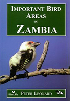
Zambia - Important Bird Areas

An essential new resource for conservationists and birders, this book isn`t just a listing, it is supplemented with excellent quality colour photos and black and white line illustrations of Zambia bird species as well as other fauna. It describes 42 Important Bird Areas identified in Zambia, including 18 National Parks. Each site entry contains a site description, detailed information on the birds and other flora and fauna to be found there, conservation issues and visitor information. There are detailed maps for each site, checklists and the final section contains useful information for visitors including details on health and safety, navigation, transport, and camping. A lengthy introduction gives an overview of Zambian biodiversity and conservation. This is an excellent
resource for all those interested in not just Zambian but African avifauna.
RIP - This product is no longer available on our network. It was last seen on 25.09.2019

This page now acts as a permanent archive for this product. Add more information using the comments box below to ensure it can still be found by future generations.

Use our search facility to see if it is available from an alternative contributor.
  • Availability: Out Of Stock
  • Supplier: Stanfords
  • SKU: 9789982811019
Availability: In Stock
£14.00

Product Description

An essential new resource for conservationists & birders, this book isn`t just a listing, it is supplemented with excellent quality colour photos & black & white line illustrations of Zambia bird species as well as other fauna. It describes 42 Important Bird Areas identified in Zambia, including 18 National Parks. Each site entry contains a site description, detailed information on the birds & other flora & fauna to be found there, conservation issues & visitor information. There are detailed maps for each site, checklists & the final section contains useful information for visitors including details on health & safety, navigation, transport, & camping. A lengthy introduction gives an overview of Zambian biodiversity & conservation. This is an excellent resource for all those interested in not just Zambian but African avifauna.

Reviews/Comments

Add New

Intelligent Comparison

Oooops!
We couldn't find anything!
Perhaps this product's unique.... Or perhaps we are still looking for comparisons!
Click to bump this page and we'll hurry up.

Price History

Vouchers

No voucher codes found.
Do you know a voucher code for this product or supplier? Add it to Insights for others to use.

Facebook

Jargon Buster

Black - A colour which does not emit any colour of the spectrum. Black absorbs all frequencies of the spectrum.
White - A colour combining all colours
Colour - The categorised spectrum of light visable to humans
Quality - An object that has quality is superior in function and finish than a less quality object.
Safety - prevents damage being caused.
illustrations - Pictures typically in books and newspapers.
Transport - Something that carries people or goods.

Supplier Information

Stanfords
Stanfords was established in 1853 and opened their iconic Covent Garden flagship store in 1901. They have become the top retailer of maps, travel books and accessories in the UK and arguably offer the largest selection of maps and travel books worldwide. Famous names such as Captain Robert Falcon Scott, Ranulph Fiennes and Michael Palin have purchased from Stanfords. They now have a shop in Bristol and both stores together with other venues operate a calendar of events including talks, book signings and exhibitions. As a specialist map retailer, the map selection is comprehensive and includes road maps, street maps and walking maps from worldwide destinations, as well as a selection of world atlases and wall maps. Books include travel guides and travel literature. Stanfords also stock globes, from miniatures made of blue marble to magnificent floor-standing globes. The website features a selection of interesting articles on travel topics.
Page Updated: 2023-11-12 20:15:36

Community Generated Product Tags

Oh No! The productWIKI community hasn't generated any tags for this product yet!
Menu