
 United Kingdom
 France
 Germany
 Netherlands
 Sweden
 USA
USA
 Italy
Italy
 Spain
Spain
More From Contributor

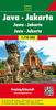
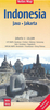
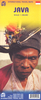
Java & Bali Periplus Travel Map
Java and Bali on a double-sided map at 1:600, 000 from Periplus, accompanied by enlargements of southern Bali and overview street plans of Jakarta and Yogyakarta. All are annotated with numerous places of interest.Java is divided between the two sides of the map, with the whole of Bali shown at the same scale of 1:600, 000 as an inset. Coverage includes the south-eastern tip of Sumatra with the Sunda Straight and Krakatoa/Krakatau National Park. Road network includes selected local roads and tracks, and gives driving distances on main and secondary routes. Railway lines and ferry connections are included and airports are marked. Also shown are internal administrative boundaries with names of the provinces. Topography is shown by colouring and relief shading to shown the main mountains.
Latitude and longitude lines are drawn at 1º intervals. The map has no index.The map includes plans of Jakarta and Yogyakarta (both at 1:100, 000) showing main traffic arteries and principal streets. An enlargement at 1:120, 000 presents in greater detail the southern tip of Bali around Denpasar, Seminyak, Kuta, Tuban, Jimbaran and Nusa Dua. All are annotated with places of interest including selected accommodation. Also provided is a distance table for Java.
Latitude and longitude lines are drawn at 1º intervals. The map has no index.The map includes plans of Jakarta and Yogyakarta (both at 1:100, 000) showing main traffic arteries and principal streets. An enlargement at 1:120, 000 presents in greater detail the southern tip of Bali around Denpasar, Seminyak, Kuta, Tuban, Jimbaran and Nusa Dua. All are annotated with places of interest including selected accommodation. Also provided is a distance table for Java.
Product Description
Reviews/Comments
Add New
Vouchers
No voucher codes found.
Do you know a voucher code for this product or supplier? Add it to Insights for others to use.
Do you know a voucher code for this product or supplier? Add it to Insights for others to use.
 Denmark